04-04-2026
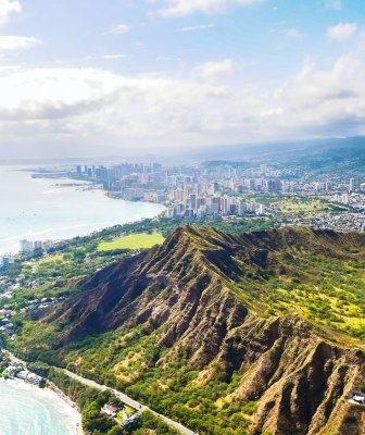
Where Is Hawaii?
Location, distances, flight times, and time zones for the Hawaiian Islands

Founder & certified Hawaii travel expert with 20+ years of experience in Hawaii tourism.
Aloha! This article may link to trusted Hawaii resources at no extra cost to you. Mahalo for your support!
Where Is Hawaii on the Map?
Hawaii sits in the central Pacific Ocean, roughly 2,400 miles southwest of the US mainland. It is the only US state located entirely outside North America.
The geographic center of Hawaii falls at approximately 20.7984 degrees North latitude, 156.3319 degrees West longitude — putting it squarely in the tropics between the Tropic of Cancer and the Equator. The islands are part of Polynesia, the vast triangle of Pacific islands that also includes New Zealand, Samoa, Tonga, and Tahiti.
On a world map, look for the middle of the Pacific Ocean between North America and Asia. Hawaii sits roughly one-third of the way from California to Japan. There is no other landmass nearby. The closest continental land is North America, and the closest populated islands are the US territories in the South Pacific, over 2,500 miles away.
That isolation shaped everything about the islands — their ecology, their culture, and the logistics of getting there.
How Far Is Hawaii from the Mainland US?
Distances from major US cities to Honolulu (measured as straight-line distance):
- Los Angeles, CA: 2,470 miles
- San Francisco, CA: 2,400 miles
- Seattle, WA: 2,680 miles
- Phoenix, AZ: 2,900 miles
- Denver, CO: 3,370 miles
- Dallas, TX: 3,780 miles
- Chicago, IL: 4,250 miles
- New York, NY: 4,960 miles
From an international perspective, Hawaii is about 3,850 miles from Tokyo, 5,070 miles from Sydney, and 7,220 miles from London. The islands occupy a unique geographic position as the most isolated population center on Earth — no other city of comparable size is farther from another continent.
Flight Times to Hawaii
All visitors arrive by air (or occasionally by cruise ship). There are no bridges, tunnels, or ferries from the mainland. Here are typical flight times to Hawaii from major cities:
From the US West Coast:
- Los Angeles to Honolulu: 5 hours 30 minutes
- San Francisco to Honolulu: 5 hours 15 minutes
- Seattle to Honolulu: 6 hours
- San Diego to Honolulu: 5 hours 45 minutes
From the US East Coast and Midwest:
- New York to Honolulu: 10-11 hours (one stop)
- Chicago to Honolulu: 9-10 hours (one stop)
- Dallas to Honolulu: 8-9 hours (nonstop or one stop)
International flights:
- Tokyo to Honolulu: 7-8 hours
- Sydney to Honolulu: 10 hours
- Vancouver to Honolulu: 5 hours 45 minutes
- London to Honolulu: 16-18 hours (one or two stops)
Most mainland flights land at Daniel K. Inouye International Airport (HNL) in Honolulu on Oahu. Direct flights also serve Maui's Kahului Airport (OGG), Big Island's Kona International Airport (KOA), and Kauai's Lihue Airport (LIH).
Hawaii's Time Zone
Hawaii uses Hawaii Standard Time (HST), which is UTC-10. The state does not observe daylight saving time — the clock never changes.
That creates a shifting gap with the mainland:
- During Pacific Standard Time (Nov-Mar): Hawaii is 2 hours behind California, 3 hours behind Mountain Time, 4 hours behind Central, and 5 hours behind Eastern.
- During Pacific Daylight Time (Mar-Nov): Hawaii is 3 hours behind California, 4 hours behind Mountain Time, 5 hours behind Central, and 6 hours behind Eastern.
The practical effect: when it is noon in Hawaii during summer, it is 3:00 PM in Los Angeles and 6:00 PM in New York. Plan your calls home accordingly.
The no-daylight-saving policy means Hawaii has relatively consistent sunrise and sunset times year-round. The sun rises between 5:50 AM and 7:10 AM and sets between 5:50 PM and 7:15 PM depending on the season.
The Hawaiian Island Chain
Hawaii is not a single island. The state consists of 137 islands, atolls, reefs, and shoals stretched across roughly 1,500 miles of the Pacific Ocean. The chain formed over millions of years as the Pacific tectonic plate drifted northwest over a volcanic hot spot that still erupts today on the Big Island.
Eight main islands make up the Hawaiian archipelago. From northwest to southeast:
- Niihau — Privately owned, restricted access. Population around 70.
- Kauai — The oldest major island, known as the "Garden Isle." Explore Kauai.
- Oahu — Home to Honolulu and Waikiki. About 70% of Hawaii's population lives here. Explore Oahu.
- Molokai — Rural and largely undeveloped. No traffic lights on the entire island.
- Lanai — Smallest inhabited island with two Four Seasons resorts.
- Maui — The "Valley Isle," second-most visited island. Explore Maui.
- Kahoolawe — Uninhabited. Former military target range, now undergoing restoration.
- Hawaii (Big Island) — Largest island in the chain and home to active volcanoes. Explore the Big Island.
The four islands most visitors travel to are Oahu, Maui, the Big Island, and Kauai. Inter-island flights connect them in 30-45 minutes.
Is Hawaii Part of the US?
Yes. Hawaii became the 50th state on August 21, 1959, when President Eisenhower signed the Hawaii Admission Act. It was the last state admitted to the Union.
A brief timeline:
- ~1000-1200 AD: Polynesian voyagers first settled the islands, navigating thousands of miles across open ocean by stars, currents, and wave patterns.
- 1778: Captain James Cook became the first European to reach Hawaii.
- 1810: King Kamehameha I unified the Hawaiian Islands into a single kingdom.
- 1893: The Hawaiian monarchy was overthrown with support from American business interests.
- 1898: The US annexed Hawaii as a territory.
- 1941: The attack on Pearl Harbor on Oahu brought the US into World War II.
- 1959: Hawaii became a state after a referendum in which 93% of voters approved statehood.
As a US state, Hawaii uses the US dollar, follows federal and state law, and requires no passport for US citizens to visit. Flights from the mainland are domestic flights.
Hawaii's Geographic Records
Hawaii holds several geographic distinctions that no other US state can claim:
- Southernmost state: Ka Lae (South Point) on the Big Island at 18.91 degrees N is the southernmost point in the United States.
- Only state entirely in the tropics: Every island sits between the Tropic of Cancer and the Equator.
- Most isolated population center on Earth: Honolulu is farther from any other city of comparable size than any other city in the world.
- Tallest mountain from base to peak: Mauna Kea on the Big Island rises 33,500 feet from the ocean floor to its summit at 13,796 feet above sea level — taller than Mount Everest measured base to peak.
- Most active volcano: Kilauea on the Big Island is one of the most active volcanoes on Earth and has been erupting intermittently for decades.
- Wettest spot in the US: Mount Waialeale on Kauai averages roughly 450 inches of rain per year.
- Only US state that grows coffee commercially: Kona coffee from the Big Island is world-renowned, and smaller farms operate on Maui, Oahu, and Kauai.
These records reflect Hawaii's extreme isolation, volcanic origins, and tropical position. They also make the islands one of the most geographically diverse places in the world — from snow-capped summits to tropical rainforests to desert-dry lava fields, all within a few hours' drive.
Start Planning Your Hawaii Trip
Now that you know where Hawaii is and how to get there, explore the islands.
Get Your Free Hawai'i Guide
Instant access — opens immediately
- Beaches, activities & top spots
- Restaurant & dining recommendations
- Maps, itineraries & insider tips
Want the full offline version? Get the Complete Hawai'i Guidebook →
Affiliate Disclosure: We may earn commissions from some travel partners (like Amazon or Expedia) which helps us maintain this site. These links are at no extra cost to you and don't impact our honest & unbiased recommendations. Remove all the ads →
×
![]()
Try out our AI Powered
Search & Chatbot →
Get Your Free Hawaii Visitor Guide
Enter your email and we'll send you instant access to our free 2026 Hawaii Starter Guide + Summary Guidesheets.