
The Big Island is 4,028 square miles. That’s bigger than all the other Hawaiian islands combined, and the terrain ranges from sea level to nearly 14,000 feet. You get tropical rainforest, barren lava fields, volcanic craters, alpine desert, and coastal cliffs — sometimes on the same hike. No other island offers this range.
These 10 trails cover the full spectrum. Some are short walks with massive payoffs. Others will test your legs and your lungs. All of them show you a side of Hawaii that most visitors never see from their resort pool.
1. Kilauea Iki Trail
| Distance: 4 miles (loop) | Difficulty: Moderate | Time: 2-3 hours |
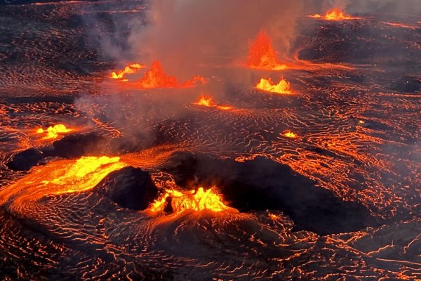
This is the hike that makes people fall in love with the Big Island. You descend 400 feet through a dense ‘ohi’a lehua forest into the floor of Kilauea Iki crater — a massive pit that held a lava lake during the 1959 eruption. The crater floor is still warm in places. Steam vents hiss through cracks in the hardened lava. You walk across it on a trail marked by rock cairns (ahu).
The contrast hits hard. One minute you’re in dripping rainforest with birdsong. The next you’re crossing a flat, cracked lava plain that looks like Mars. Start at the Kilauea Iki Overlook on Crater Rim Drive. Go counterclockwise — descend through the forest first and cross the crater floor second. The trail is well-maintained but the crater floor section has uneven footing. Sturdy shoes are non-negotiable.
2. Pololu Valley Trail
| Distance: 1 mile (out and back) | Difficulty: Moderate | Time: 45 minutes - 1 hour |
Short but steep. The trail drops about 420 feet from the lookout to a black sand beach at the bottom of Pololu Valley on the Kohala Coast. The lookout alone is worth the drive — towering green cliffs dropping into white surf. But the beach below is where it gets real. You’re standing at the mouth of a valley that reaches miles inland, with nobody around.
The trail is slippery when wet (which is often). Use the exposed tree roots as steps. Swimming is dangerous here — strong rip currents and shore break. Come for the scenery, not the water. The drive from Waimea takes about 30 minutes through ranch country and the small town of Hawi.
3. Captain Cook Monument Trail (Kealakekua Bay)
| Distance: 3.6 miles (out and back) | Difficulty: Moderate-Hard | Time: 2-3 hours |
The trail drops 1,300 feet over 1.8 miles to Kealakekua Bay — one of the best snorkeling spots in Hawaii. The bay is a marine sanctuary. Spinner dolphins cruise through regularly. The coral is healthy and the water clarity is absurd. The white obelisk marking where Captain Cook was killed in 1779 sits at the shore.
Here’s the catch: the descent is easy, but the climb back out in afternoon heat is brutal. Bring at least 2 liters of water per person. There’s no shade on most of the trail and no facilities at the bottom. Start early. Some hikers bring snorkel gear in a daypack and spend time in the water before the slog back up. It’s worth the weight.
4. Devastation Trail
| Distance: 1 mile (out and back) | Difficulty: Easy | Time: 30 minutes |
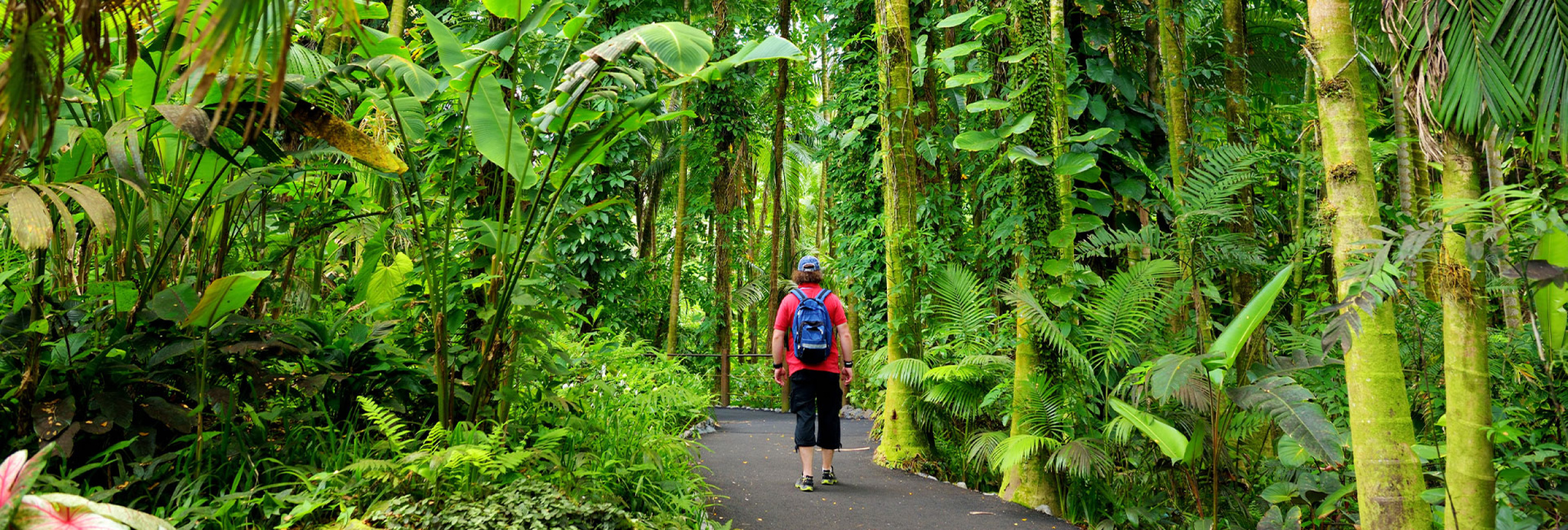
A paved, flat trail through a landscape that looks post-apocalyptic. The 1959 Kilauea Iki eruption buried this area in cinder and pumice. Skeletal ‘ohi’a trees stand like sentinels against a backdrop of volcanic rubble. New growth pushes through the cinders — ferns, mosses, small shrubs — a real-time demonstration of ecological recovery.
This is the most accessible hike on the entire list. Wheelchair-friendly for most of its length. Connects to the Kilauea Iki Trail if you want to extend your walk. It’s a 10-minute drive from the park visitor center.
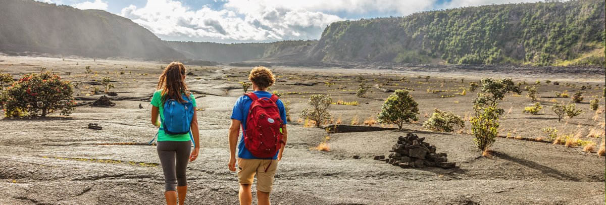
5. Crater Rim Trail
| Distance: Varies (up to 11 miles full loop) | Difficulty: Easy to Moderate | Time: 1-6 hours depending on sections |
The trail that circles Kilauea caldera. You don’t have to do the whole thing — most people pick a section. The segment from the Kilauea Visitor Center to the Steam Vents is an easy 1.5-mile walk through native forest with views into the caldera. The stretch from the Jaggar Museum area toward the Keanakako’i Crater gives you the most dramatic volcanic landscape.
Some sections remain closed due to the 2018 summit collapse and ongoing eruption activity. Check the NPS trail conditions page before you go. What’s open is spectacular.
6. Waipio Valley
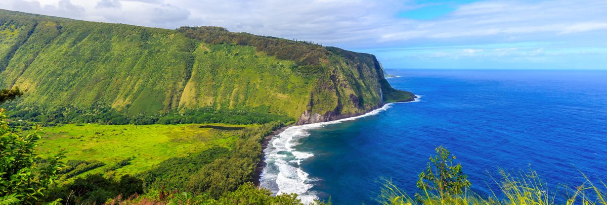
| Distance: 2 miles (out and back, road to beach) | Difficulty: Hard (steep grade) | Time: 1.5-2 hours |
Waipio is the Valley of the Kings — the largest and most accessible of the Kohala Coast’s deep amphitheater valleys. The road down is a 25% grade, the steepest road in Hawaii. No rental cars allowed. You walk it or take a shuttle tour.
The black sand beach at the bottom stretches wide, with a waterfall visible from shore. The valley floor has taro farms, wild horses, and a quiet that settles over you once you leave the road behind. Access rules have changed in recent years, so check current regulations before heading down. Respect the valley — it’s home to residents and holds deep cultural significance.
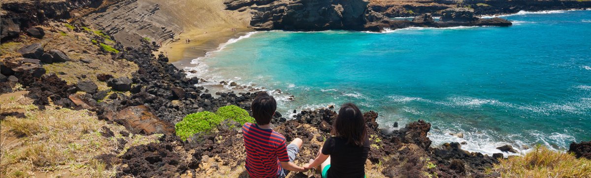
7. Papakōlea Green Sand Beach
| Distance: 5 miles (out and back) | Difficulty: Moderate | Time: 2-3 hours |
One of only four green sand beaches in the world. The olivine crystals that give it that color come from the eroding Pu’u Mahana cinder cone — the remnant of a 49,000-year-old volcanic eruption. The beach sits in a cove at the base of the cone, sheltered from wind.
The hike from the parking area at South Point follows a rough 4WD road across open, wind-blasted grassland. There’s no shade, no water, and no services. The wind can be fierce — this is the southernmost point in the United States and it’s exposed. Some locals offer rides in pickup trucks for a fee. The hike itself is flat but long. Bring sun protection, water, and a sense of adventure.
8. Pu'u Huluhulu Trail
| Distance: 1.5 miles (loop) | Difficulty: Easy | Time: 45 minutes |
A kipuka — an island of old-growth forest surrounded by newer lava flows. Pu’u Huluhulu is a forested cinder cone between Mauna Loa and Mauna Kea, rising from the Saddle Road lava fields. The trail loops through dense native forest with ‘ohi’a, koa, and tree ferns. Endangered Hawaiian hawks (io) and honeycreepers live here.
The trailhead is at the Mauna Kea Access Road junction on Saddle Road (Highway 200). From the summit of the cinder cone, you get simultaneous views of Mauna Kea, Mauna Loa, and Hualalai — three massive volcanoes in a single panorama. Few tourists come here. It’s a local favorite.
9. Akaka Falls Loop
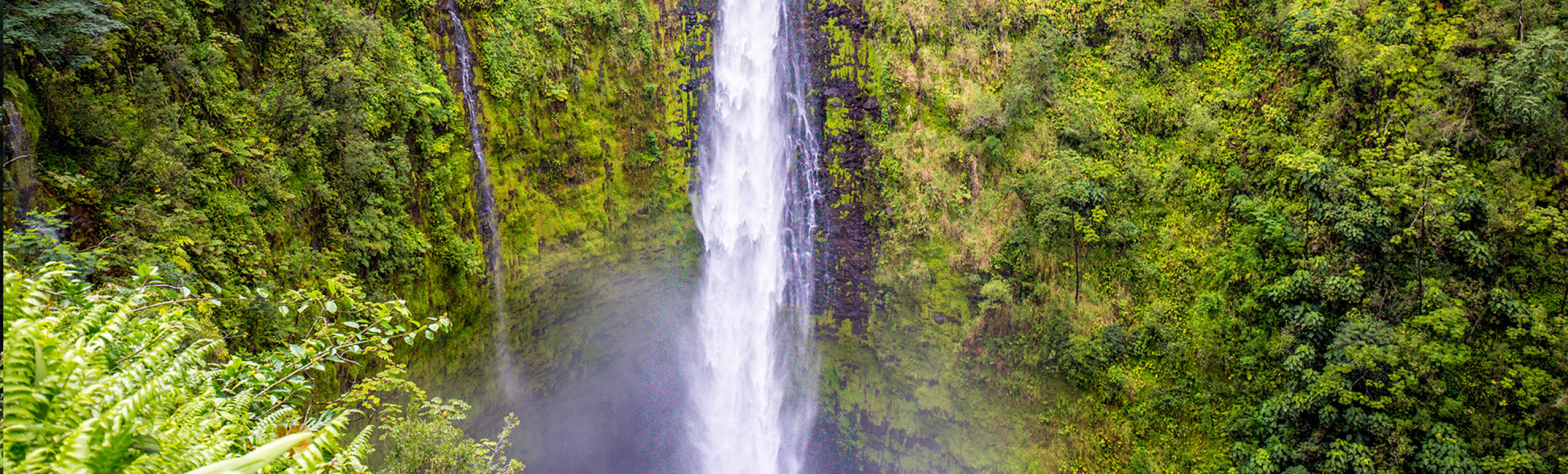
| Distance: 0.4 miles (loop) | Difficulty: Easy | Time: 20-30 minutes |
A short paved loop through tropical rainforest that delivers two waterfalls. Kahuna Falls (100 feet) comes first. Then Akaka Falls — 442 feet of free-falling water plunging into a gorge choked with tropical vegetation. It’s one of the tallest accessible waterfalls in Hawaii.
The park is 15 minutes north of Hilo off Highway 19. Entrance fee is $5 per vehicle through the state parks system. The trail has steps and is paved throughout. Humidity is high year-round — the area gets over 100 inches of rain annually. That rain is why everything is impossibly green and why the falls run strong.
10. Mauna Kea Summit
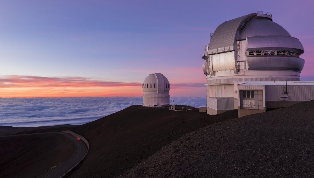
| Distance: 6 miles (Visitor Center to summit, out and back) | Difficulty: Very Hard | Time: 5-7 hours |
The tallest point in Hawaii at 13,796 feet. From the Visitor Information Station at 9,200 feet, the trail climbs through alpine desert — no trees, sparse vegetation, loose volcanic cinder. The air at the summit has 40% less oxygen than sea level. Altitude sickness is a genuine risk. Headaches, nausea, and shortness of breath are common.
Most visitors drive the summit road (4WD required above the Visitor Station). Hiking earns you the experience in a different way. You feel every foot of elevation gain. The summit views include Hilo Bay, Mauna Loa, Haleakala on Maui (on clear days), and the observatory domes that make this one of the world’s premier astronomical sites.
Mauna Kea is sacred to Native Hawaiians. The summit is the realm of Poliahu, the snow goddess. Treat it with the respect it deserves. Stay on designated trails, don’t stack rocks or leave anything behind, and follow all posted guidelines.
Hiking Tips for the Big Island
Start early. Morning light is best for photos, temperatures are cooler, and afternoon rain showers are common on the windward (east) side. Most trails are less crowded before 9 AM.
Water is everything. The Big Island’s lava rock absorbs heat. Trails without tree cover turn into ovens by midday. Carry more water than you think you need — 1 liter per hour of hiking in exposed terrain.
Footwear matters. Lava rock tears up sandals and soft-soled shoes. Many trails cross uneven ‘a’a lava or muddy forest floor. Trail runners or hiking shoes with good tread are the minimum. Boots for Mauna Kea and the Captain Cook trail.
Check conditions. Volcanic activity, weather, and trail damage can close sections without much notice. The National Park Service and DLNR trail system post current conditions.
Rental car tip: A car is essential for reaching Big Island trailheads — many are 30-60 minutes from resort areas. Book through Discount Hawaii Car Rental for the best rates.
Explore the Big Island
More guides for planning your Big Island adventures.