03-08-2025
Hawaii Volcanoes National Park
Located within the Volcano Region on Big Island

Founder & certified Hawaii travel expert with 20+ years of experience in Hawaii tourism.
Aloha! This article may link to trusted Hawaii resources at no extra cost to you. Mahalo for your support!

HVNP Entrance Sign
About Hawaii Volcanoes National Park
Big Island of Hawaii
Originally founded in 1916, Hawaii Volcanoes National Park (HVNP) is a living, breathing testament to the awesome power of Mother Nature. HVNP is located 30 miles southwest of Hilo and 96 miles southeast of Kona. It's open year-round, 24 hours a day.
HVNP is home to Kilauea Volcano, the most continuously active volcano in the world, and the park offers the unique experience of walking on land that is younger than you are. Visitors are also witness to the world's largest volcano Mauna Loa at 13,677 feet. Mauna Loa, meaning 'long mountain,' encompasses a huge chunk of the Big Island. In recognition of its outstanding natural values, Hawai'i Volcanoes National Park has been honored as an International Biosphere Reserve and a World Heritage Site.
The park encompasses 333,000 acres of natural wonders and is situated at 4,000 feet above sea level. With its wealth of trails, drives, and activities you will need at least two days to fully experience all the park has to offer.
2025-2026 Construction Notice
Hawaiʻi Volcanoes National Park has begun a two-year construction project to repair, improve or remove damaged buildings and infrastructure at the summit of Kīlauea. Park visitors and tour operators should expect delays at the entrance station, temporary area closures, and limited parking.
Delays and lack of parking will be even more severe during periods of high visitation such as during an eruption and the traditional busy months of December, January, June, July, and August.
The construction project includes:
- Removal of the earthquake-damaged Jaggar Museum and Hawaiian Volcano Observatory buildings and temporary closure of the restrooms at Uekahuna
- A new roundabout west of the entrance station to improve safety and traffic flow
- Construction of a new Hawaiian Volcano Observatory field station west of Kilauea Military Camp
- Temporary closure and complete renovation of the Kilauea Visitor Center and adjacent restrooms

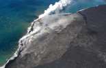
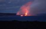
Kilauea East Rift Zone Eruption in 2018
Park & Volcano Eruption Updates
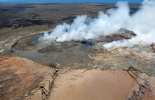
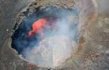
There have been several big changes lately at Kilauea volcano - especially at and within Kilauea Caldera, Halemaumau Crater, Pu'u O'o vent, and along the east rift zone. New (geologically speaking) seismic and visible activity started at Kilauea caldera within Halemaumau in mid-June 2007, and ongoing events between 2007-2008 necessitated several area closures within the park. A lava lake would eventually become visible at the summit within Halemaumau Crater. Beginning April 30, 2018, at the summit when the crater floor collapsed, and into early May 2018, another set of seismic events caused the lava lake to drain from the summit of Kilauea, and a new eruption subsequently began within the eastern rift zone (within Puna district). This eruption, which mostly occurred from 'Fissure 8,' in the Leilani Estates subdivision, continued until early August 2018, at which point the eruption had nearly subsided. On December 5, 2018 - the eruption was declared officially ended. On December 20, 2020, at approximately 9:30 pm HST the USGS Hawaiian Volcano Observatory detected a new glow within Halemaumau crater at the summit of Kilauea Volcano. This eruption continued until May 2021, and as of early 2025, has since erupted on and off again at Kilauea's summit caldera and surrounding areas.
Ongoing Eruption Updates
This situation often rapidly evolving and the Hawaii Volcanoes Observatory will continue to issue statements when more information is available to the public. For now, you can receive ongoing eruption updates by following the social media accounts of the Hawaii Volcanoes National Park (Facebook, Instagram, and Twitter). You can also view the live cameras located at the Kilauea summit.
You can also always check our Where is the Lava Located page to read more about recent lava flows, including updates on the current eruption.
We encourage visitors to check the USGS Volcano Update page before visiting the park.
Operating Hours
Hawai'i Volcanoes National Park is open 24 hours a day year-round. Kilauea Visitor Center is open daily from 9:00 a.m. to 5:00 p.m. Hours are subject to change; find the current hours at the national park website.
Hawaii Volcanoes National Park Maps
Here we've included an updated Hawai'i Volcanoes National Park Map. Larger maps of the complete park can be found in the maps section of the national park website.

National Park Summit Area (2024)
Experiencing Hawaii Volcanoes National Park
One of the best ways to see Volcanoes National Park is the Volcano Van. They offer exciting volcano tours leaving from the major resort destinations of Hilo, Kona, and Kohala.
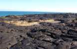
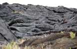
If a guided tour, which we do highly recommend, isn't for you though - rest assured that you can always opt to view the park from the seat of your own car by taking the park's two primary drives: Crater Rim Drive, (Update: much of this drive has closed, but portions remain open - check with the Visitor Center), and Chain of Craters Road which will receive visitors from the caldera to the coast for a possible glimpse of lava entry into the ocean. A hike out to the current lava flow (when possible) offers a once-in-a-lifetime chance to view Mother Nature at work up close. Check out our companion entry, Where is the Lava Located, for more details.
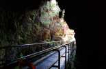
Hiking is the best way to get a real sense of the diversity of plant and animal life in HVNP. Some favorite trails are Kilauea Iki Trail, Halemaumau, Nahuku (Thurston Lava Tube), Devastation Trail, and many more.

Park Entrance Fees
Entrance to the park (a seven-day permit) is $30.00 per vehicle as of this writing. Fees for those arriving by commercial bus or tour vary by passenger capacity. A Hawaii Tri-Park pass also may be purchased for $50.00 which allows access for 1 full year at Hawai'i Volcanoes National Park, Haleakala National Park, and Pu'uhonua o Honaunau National Historical Park.
Additional Park Information
The volcano is a living, breathing park that has an ever-changing landscape. For updates on any closings in HVNP visit Alerts & Area Closings.
You never know when Madame Pele will send her lava flows but the crew at HVNP keeps close tabs on the flows. Use extra caution if you have any respiratory or heart problems or are traveling with the elderly, children or pregnant women. Generally, it is wise to determine the quality of the air in the park prior to visiting.

HVNP in 2025
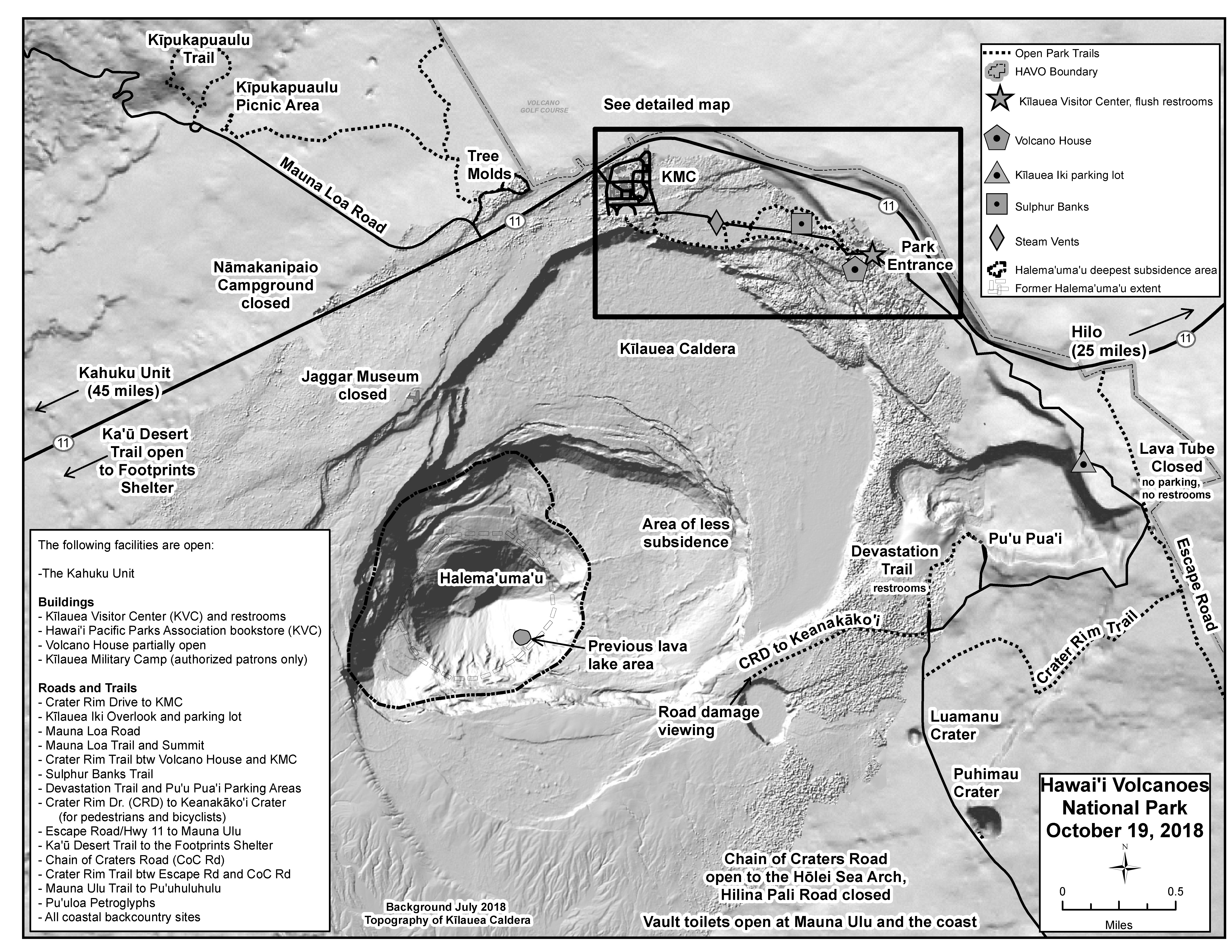
Detailed map with all structures, roads, and trail conditions.
Location & Getting to Hawaii Volcanoes National Park
Hawaii Volcanoes National Park is located on the Big Island of Hawaiii. From Hilo: it's 30 miles southwest on Highway 11; from Kailua-Kona: it's 96 miles southeast on Highway 11, or 125 miles through Waimea town and Hilo via highways 19 and 11 respectively.
Top Hiking Trails in the Park
Published by: John C. Derrick
Founder & certified Hawaii travel expert with 20+ years of experience in Hawaii tourism.
Hawaii Volcanoes National Park Reviews
Guidereview:
A (based on 4,273 visitor reviews)Geolocation Data
Geographic Coordinates
Latitude: 19.4291212
Longitude: -155.2552908
Hawaii Safety Information
Hawaii Volcanoes National Park Photo Gallery


Recommended Tours Nearby
Affiliate Disclosure: We may earn commissions from some travel partners (like Amazon or Expedia) which helps us maintain this site. These links are at no extra cost to you and don't impact our honest & unbiased recommendations. Remove all the ads →
×
![]()
Try out our AI Powered
Search & Chatbot →