

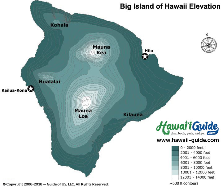
The Big Island is by far the largest Hawaiian Island, as well as the most diverse in terms of climate. With so many different regions, elevations, and precipitation clusters, the contrasts can be quite stark. That's why we're including these handy maps here- to help you get a better idea of what to expect during your stay.
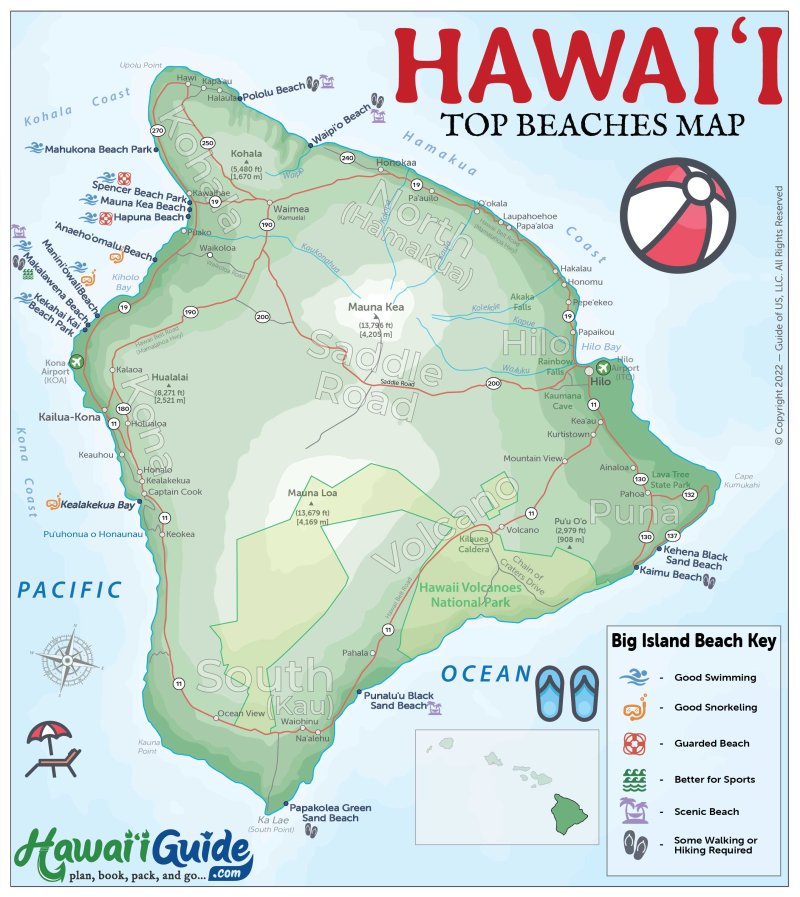
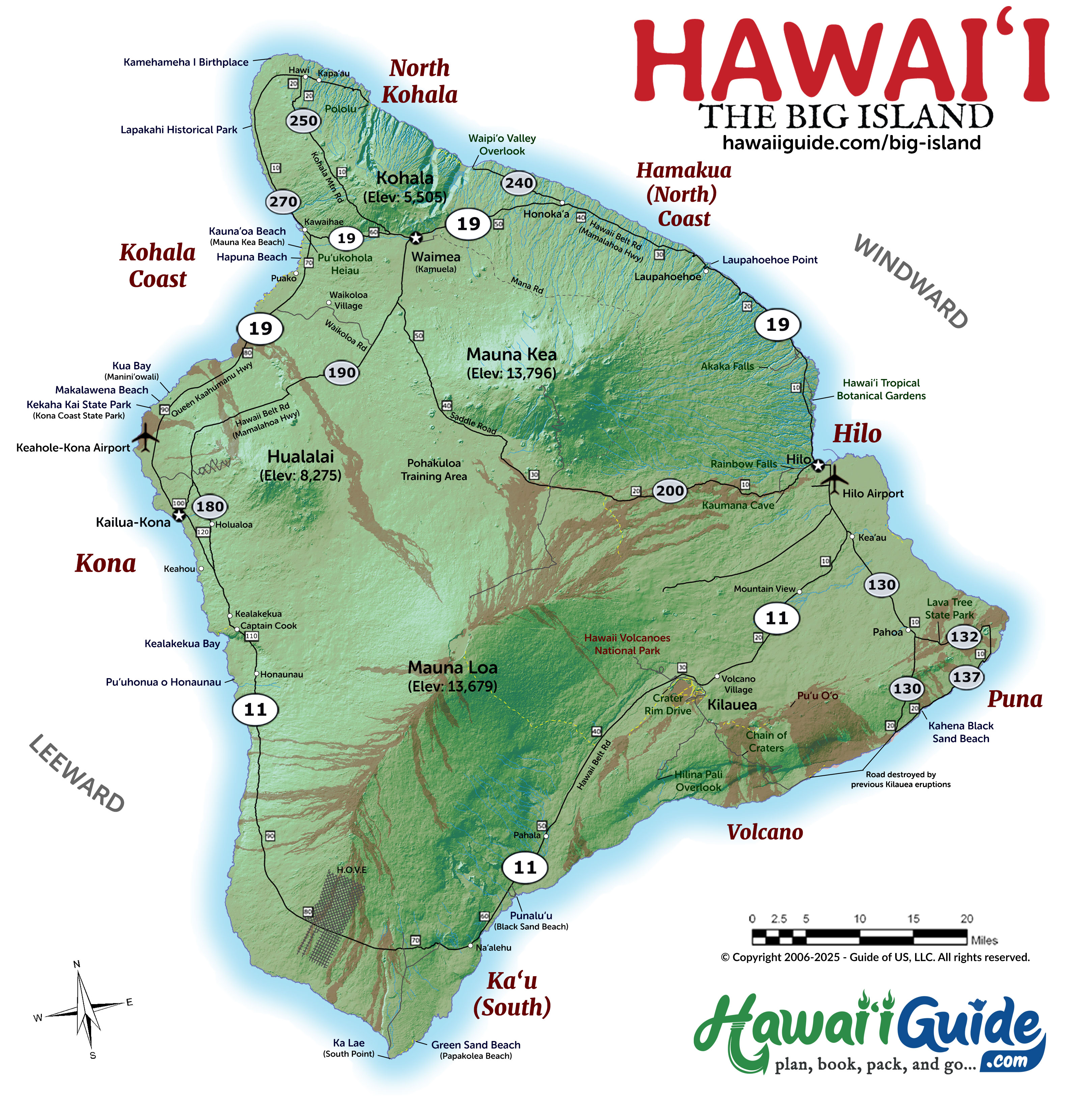
Below you'll several different maps of the Big Island of Hawaii, including both a simple (with mileage), a top beaches map, and a detailed map of the Big Island of Hawaii. Any map can be clicked on to enlarge it to full size.
Please also note that due to Kilauea's periodically ongoing eruptions, some areas around the Kilauea volcano, in particular, are subject to have changed prior to your visit.
Big Island Regions at a Glance
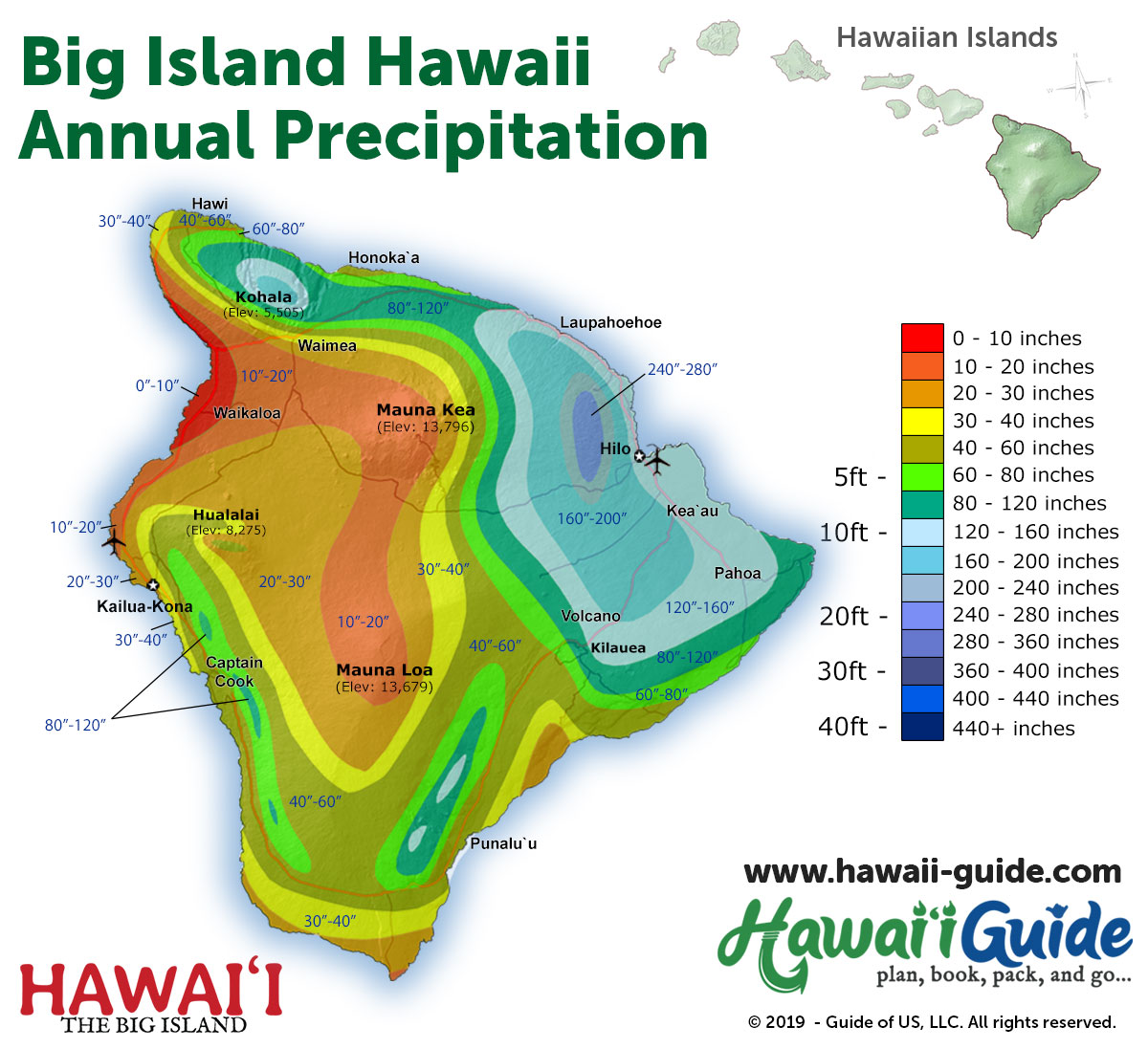
The Big Island is larger than all the other Hawaiian islands combined. That size creates dramatically different climate zones and landscapes across the island — from Sahara-dry lava fields on the west coast to soaking-wet rainforest on the east.
Kona Coast (West Side)
Where most visitors stay. The Kohala Coast resort corridor stretches from Kona airport north to Mauna Lani and Mauna Kea resorts. Kailua-Kona town has restaurants, shops, and the Kona coffee belt in the hills above town. The leeward side is dry and sunny — rain here is rare. Kealakekua Bay (Captain Cook monument and top snorkeling) is 20 minutes south of Kona.
Hilo & Hamakua Coast (East Side)
The rainy, lush side. Hilo is the Big Island's largest town — it has Rainbow Falls, Akaka Falls, and a genuine local character that the resort coast doesn't. The Hamakua Coast stretches north from Hilo with waterfalls and tropical agriculture. It rains almost daily, which is why everything is this green. Pack a rain jacket.
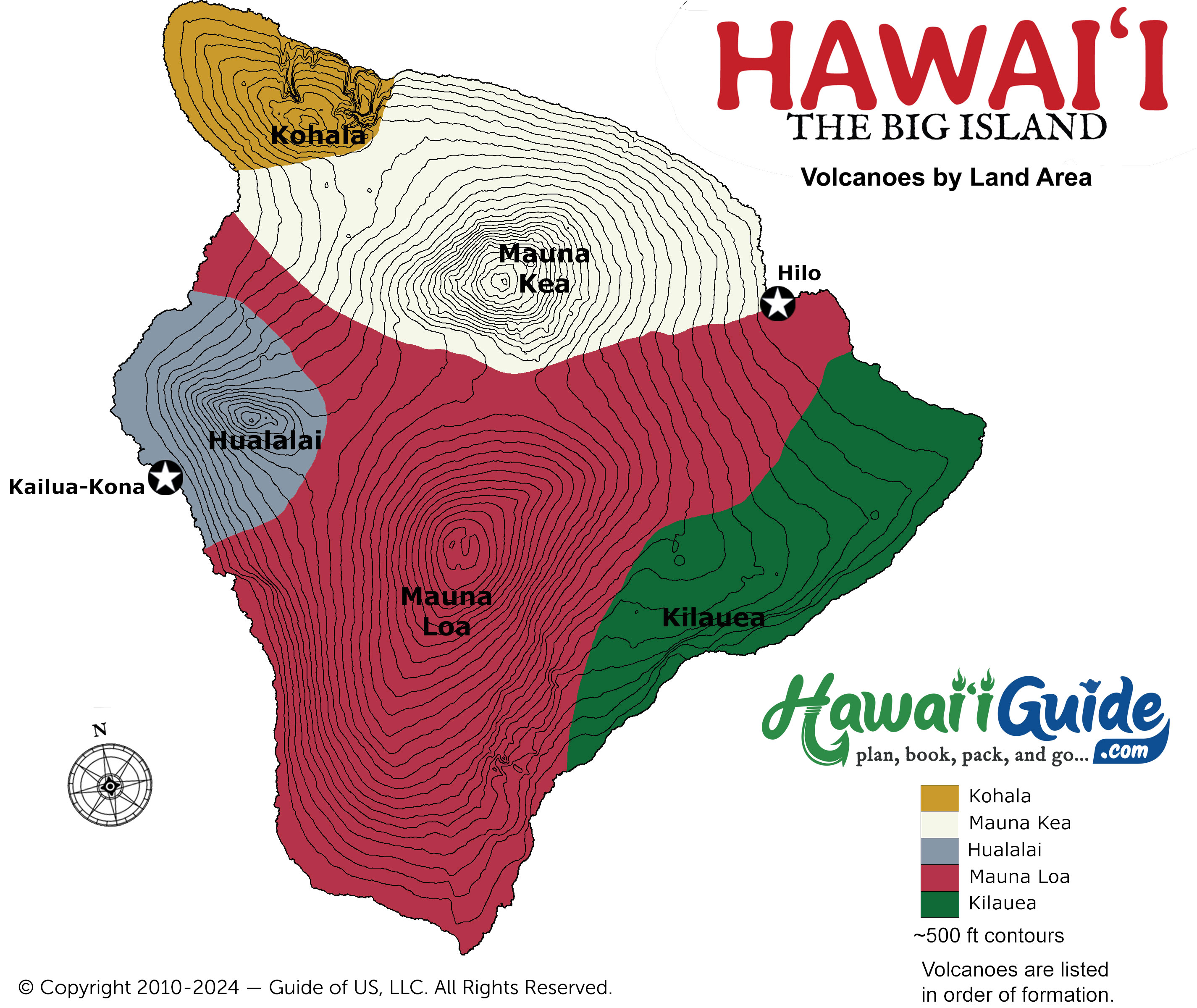
Volcano Region (Southeast)
Hawaii Volcanoes National Park is the main draw — Kilauea, one of the most active volcanoes on Earth, and Mauna Loa, the world's largest by volume. The park has steam vents, lava tubes, crater rim trails, and active eruption viewing when conditions allow. The town of Volcano (elevation 4,000 ft) has B&Bs and restaurants and feels nothing like the rest of Hawaii. Cool, misty, and quiet.
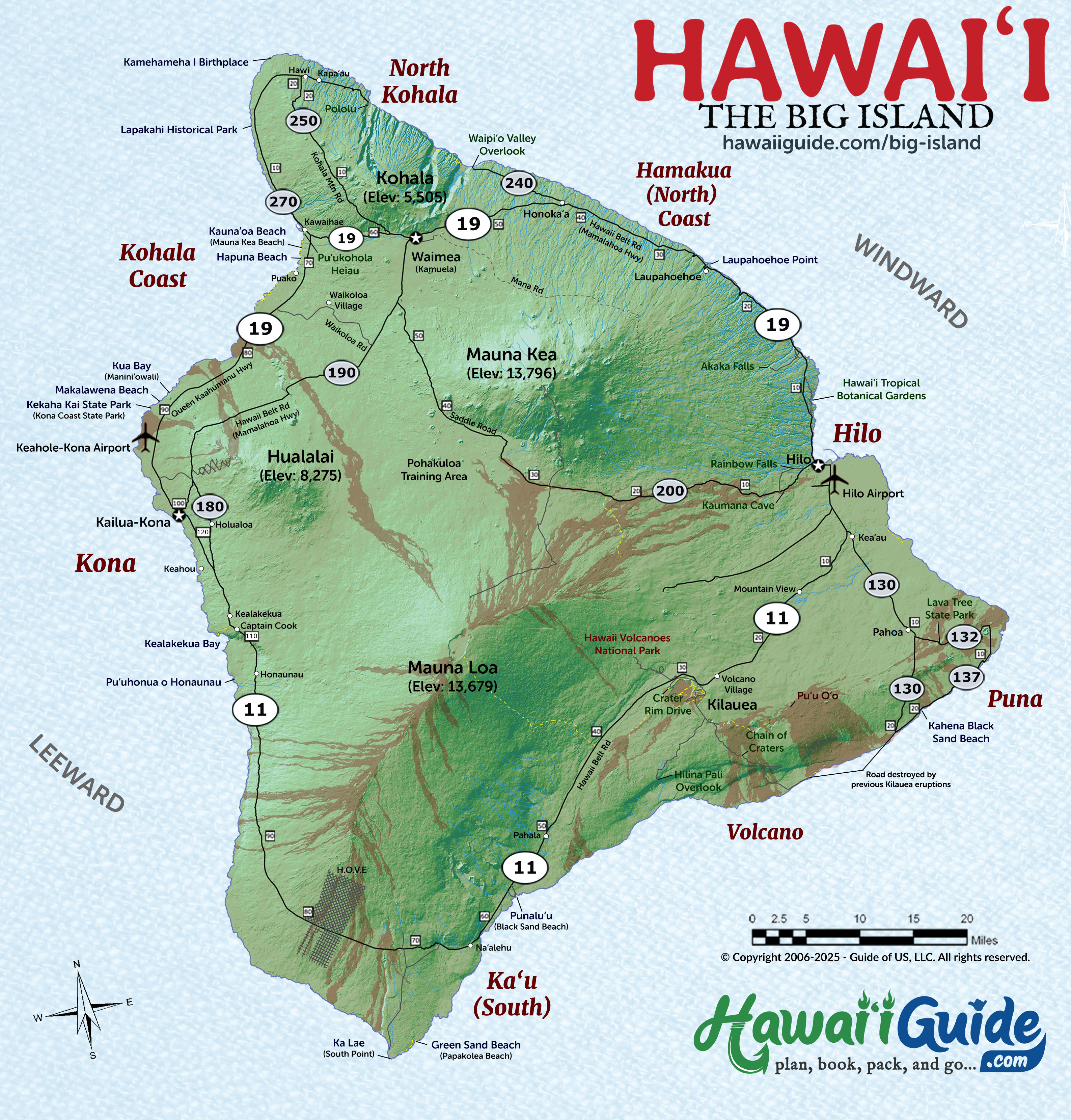
Kohala (North)
The oldest part of the island. Hawi and Kapaau are small historic towns at the northern tip with the original King Kamehameha statue. The Kohala mountain road has views across to Maui. Pololu Valley — a dramatic cliff-lined valley — is at the end of Highway 270. Less visited than the south but worth the drive.
Kau & South Point (South)
The most remote region. South Point (Ka Lae) is the southernmost point in the United States. Papakolea (Green Sand Beach) is a 5-mile round-trip hike from there — one of only four green sand beaches in the world. Punalu'u Black Sand Beach, between Kona and Volcano, has Hawaiian green sea turtles hauled out on the sand almost every day.
Waipi'o Valley & Mauna Kea (Interior)
Waipi'o Valley — the Valley of the Kings — drops 900 feet to a black sand beach flanked by 2,000-foot cliffs. You can view it from the lookout or hike the steep road down (4WD only for vehicles). Mauna Kea's 13,796-foot summit offers the best stargazing on Earth — observatories from 13 countries sit at the top. The visitor station at 9,200 feet has free nightly stargazing programs.
Updated Big Island Travel Map Packet + Guidesheet
Updated with a new high-resolution map of the Big Island. Includes most major attractions, all major routes, airports, and a chart with estimated Big Island of Hawaii driving times.
PDF packet now additionally includes a Big Island Beaches Map.
Our 2026 Big Island of Hawaii Summary Guidesheet includes the top must-see & do attractions, best times to visit, where to stay briefing, airport detail, a monthly weather summary, and where to find the most noteworthy local ono 'grindz' (best eats) on the Big Island.
-File is formatted as a print-ready PDF document
Printable Free Big Island of Hawaii Maps
Click any map to view full size. All maps are free to download and print.
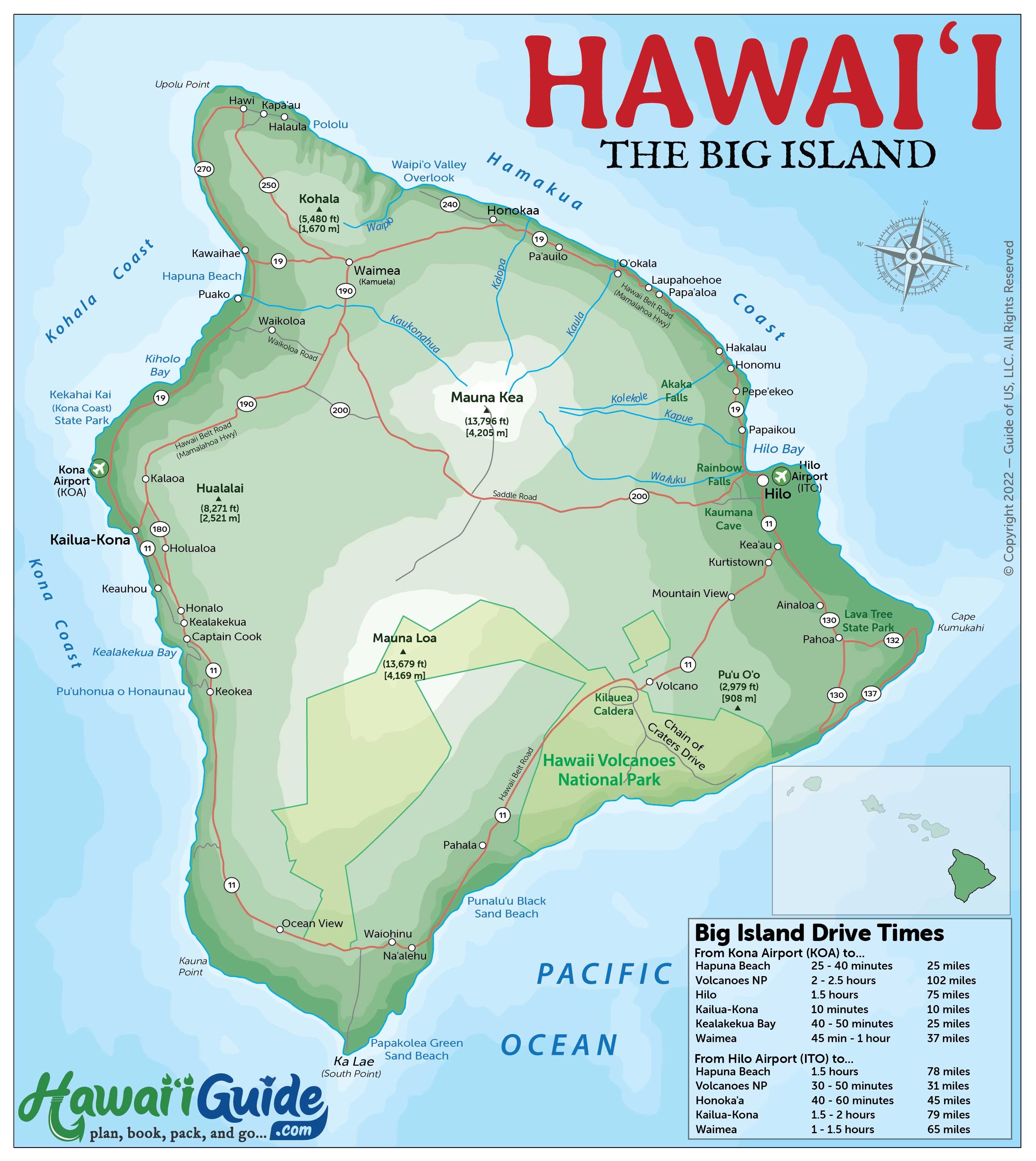
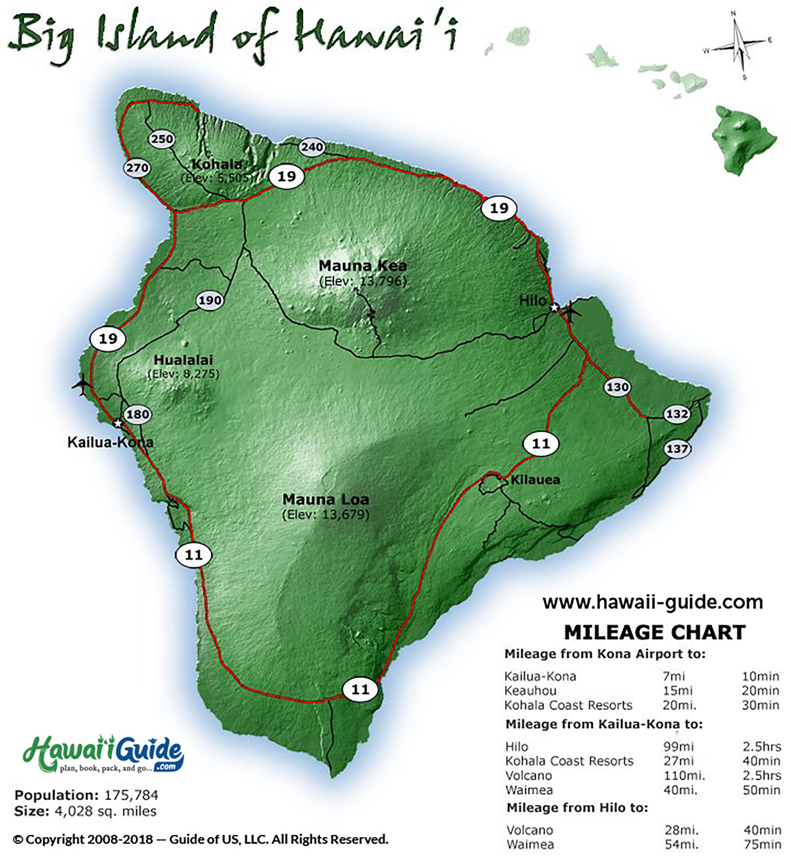
Big Island Driving Times Between Destinations
The Big Island is huge — distances are real here. Unlike Oahu or Maui, a 30-mile drive can take an hour on winding two-lane highways. Plan accordingly.
| From | To | Distance | Drive Time |
|---|---|---|---|
| Kona Airport (KOA) | Kailua-Kona Town | 7 mi | 15 min |
| Kona Airport (KOA) | Kohala Coast Resorts | 20 mi | 25-30 min |
| Kailua-Kona | Hilo (via Hwy 19 north) | 92 mi | 2-2.5 hrs |
| Kailua-Kona | Hawaii Volcanoes NP | 96 mi | 2.5 hrs |
| Kailua-Kona | Kealakekua Bay | 12 mi | 20 min |
| Hilo | Hawaii Volcanoes NP | 30 mi | 45 min |
| Hilo | Akaka Falls | 15 mi | 25 min |
| Kona / Kohala | Waipi'o Valley Lookout | 52 mi | 1.5 hrs |
| Kona | Mauna Kea Visitor Station | 43 mi | 1 hr 15 min |
| Kona | South Point / Green Sand Beach | 75 mi | 2 hrs |
Two airports serve the Big Island. If your primary goal is volcanoes, consider flying into Hilo (ITO) instead of Kona — it puts you 45 minutes from Hawaii Volcanoes National Park instead of 2.5 hours. Compare Big Island rental car rates.
Big Island Resources
Planning a Hawaiian vacation can seem daunting; you probably have so many questions: What are the best sights? When is the best time to visit Big Island? How can I see lava? Where is the best surfing? All the information you need to plan your perfect Hawaiian getaway is right here.
