We’re here to provide you with the best Maui maps to make the most of your time in Maui, Hawaii. Whether you’re looking for the most beautiful beaches, the best hikes, or the classic Road to Hana, you’ll find the perfect map here.
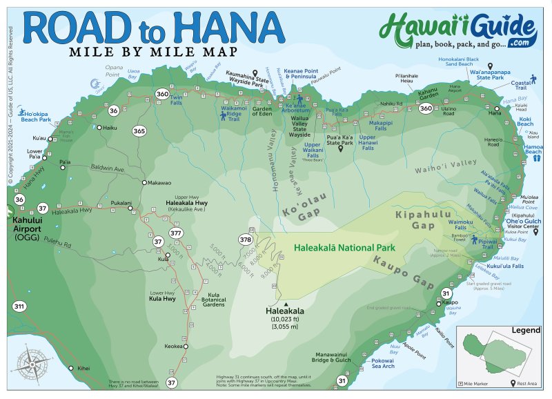
With our maps, you can plan your vacation with ease and enjoy your time in Maui to the fullest. We’ve got the classic Road to Hana map, which will guide you through the lush rainforest and along the iconic winding roads. This map will help you to make the most of your time and experience the best of what the Road to Hana has to offer.
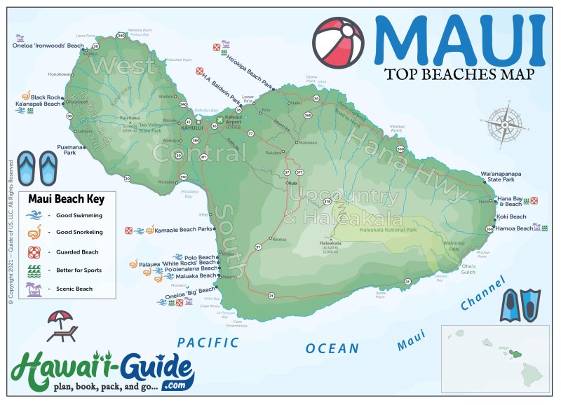
We’ve also got a map highlighting all of the top beaches in Maui, so you can choose the best spot for your beach day. All of our maps are easy to use and include everything you need to know to make the most of your time in Maui.
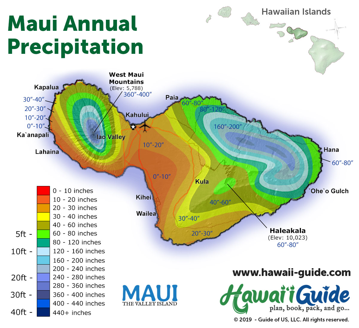
Our latest Maui Maps include a printable basic Maui map, a new detailed Hana Highway map, and a Maui annual precipitation map.
If you'd prefer a printed map, our Road to Hana book, Hana Highway - Mile by Mile, features several detailed maps of nearly all of east and central Maui.
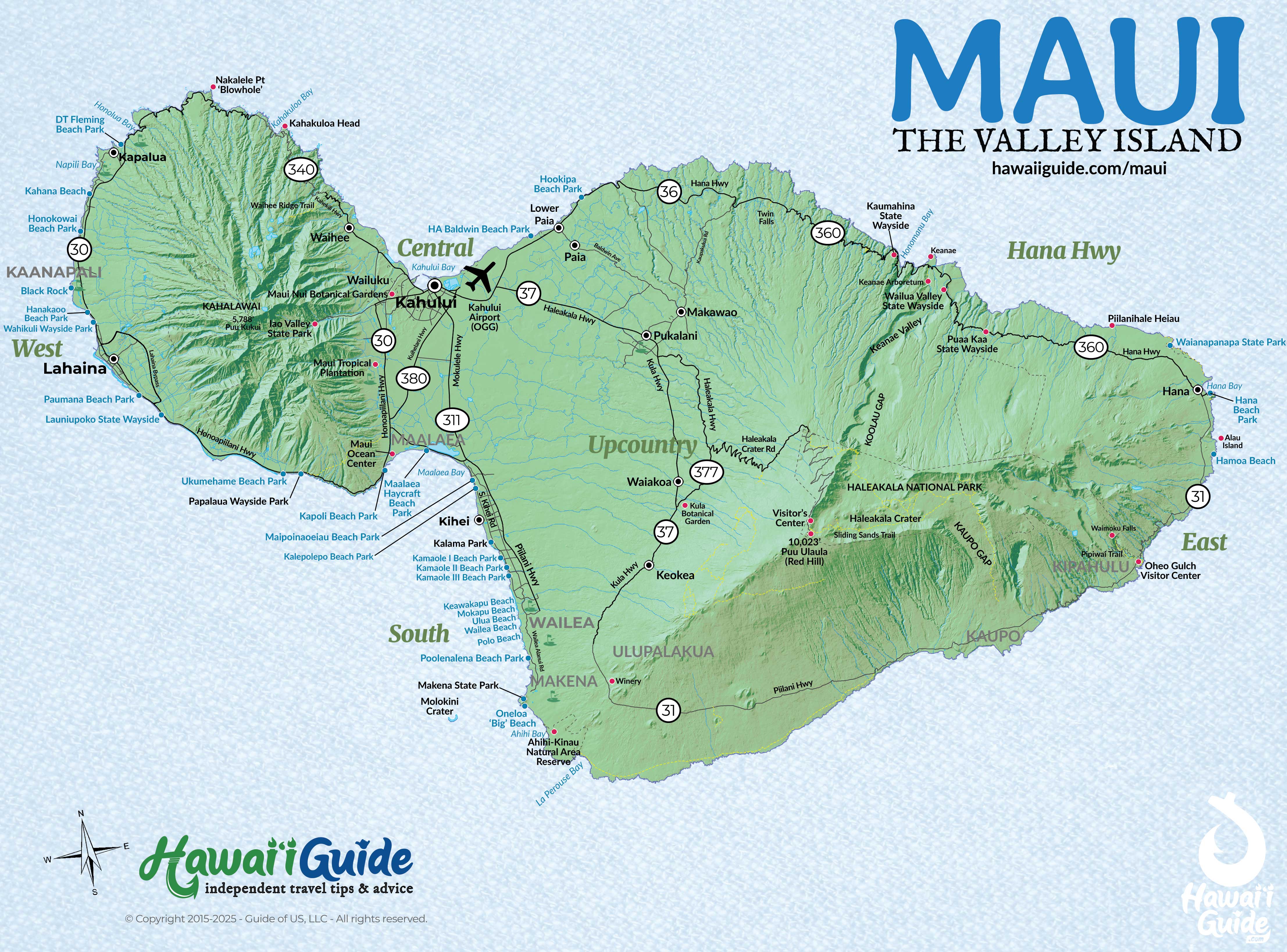
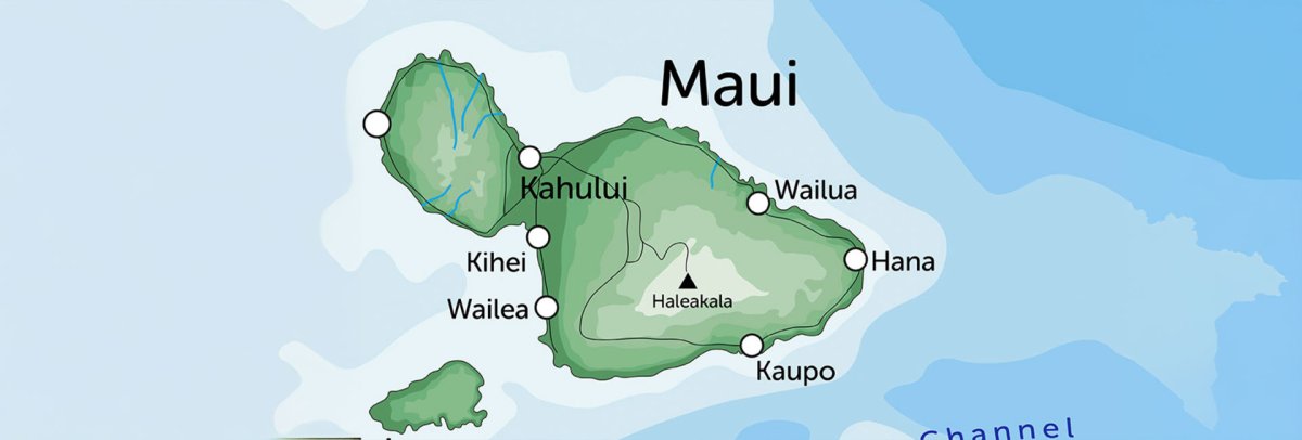
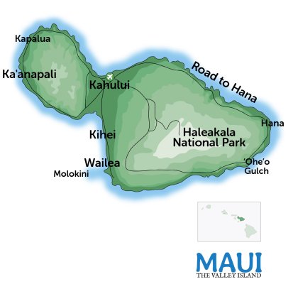
Maui Regions at a Glance
Maui splits into five distinct regions, each with a different character. Knowing the layout saves you time and helps you pick the right home base.
West Maui (Lahaina / Ka'anapali / Kapalua)
The resort corridor. Ka'anapali Beach and Kapalua Bay anchor miles of golden sand, with restaurants, shops, and snorkel spots within walking distance. Most visitors who want a classic beach resort experience stay here. The historic town of Lahaina is rebuilding after the August 2023 wildfire.
South Maui (Kihei / Wailea / Makena)
Maui's dry side. Kihei is the budget-friendly option with condos and affordable dining. Wailea is upscale resorts and manicured golf courses. Past Wailea, Makena's Big Beach is one of the best stretches of sand in Hawaii. South Maui gets more sun than anywhere else on the island.
Central Maui (Kahului / Wailuku)
Where the airport is. Most visitors pass through but don't stay. Kahului has big-box stores and the main harbor. Wailuku has local restaurants and access to 'Iao Valley State Park. Fill up on gas and groceries here before heading anywhere else on the island.
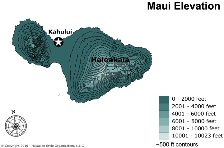
Upcountry Maui (Kula / Makawao / Haleakala)
The cool, elevated interior. Kula sits at 3,000 feet with views across the entire island. Makawao is a small cowboy town with art galleries. Haleakala's summit reaches 10,023 feet — sunrise reservations fill up weeks in advance. Temperature drops roughly 3 degrees per 1,000 feet of elevation.
East Maui (Hana / Kipahulu)
The Road to Hana side. Lush rainforest, 59 one-lane bridges, 620 curves, and some of the most dramatic waterfalls in the state. Hana itself is a quiet, remote community. Past Hana, Kipahulu has 'Ohe'o Gulch (Seven Sacred Pools) and the Pipiwai Trail to 400-foot Waimoku Falls.
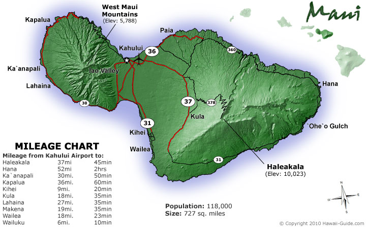
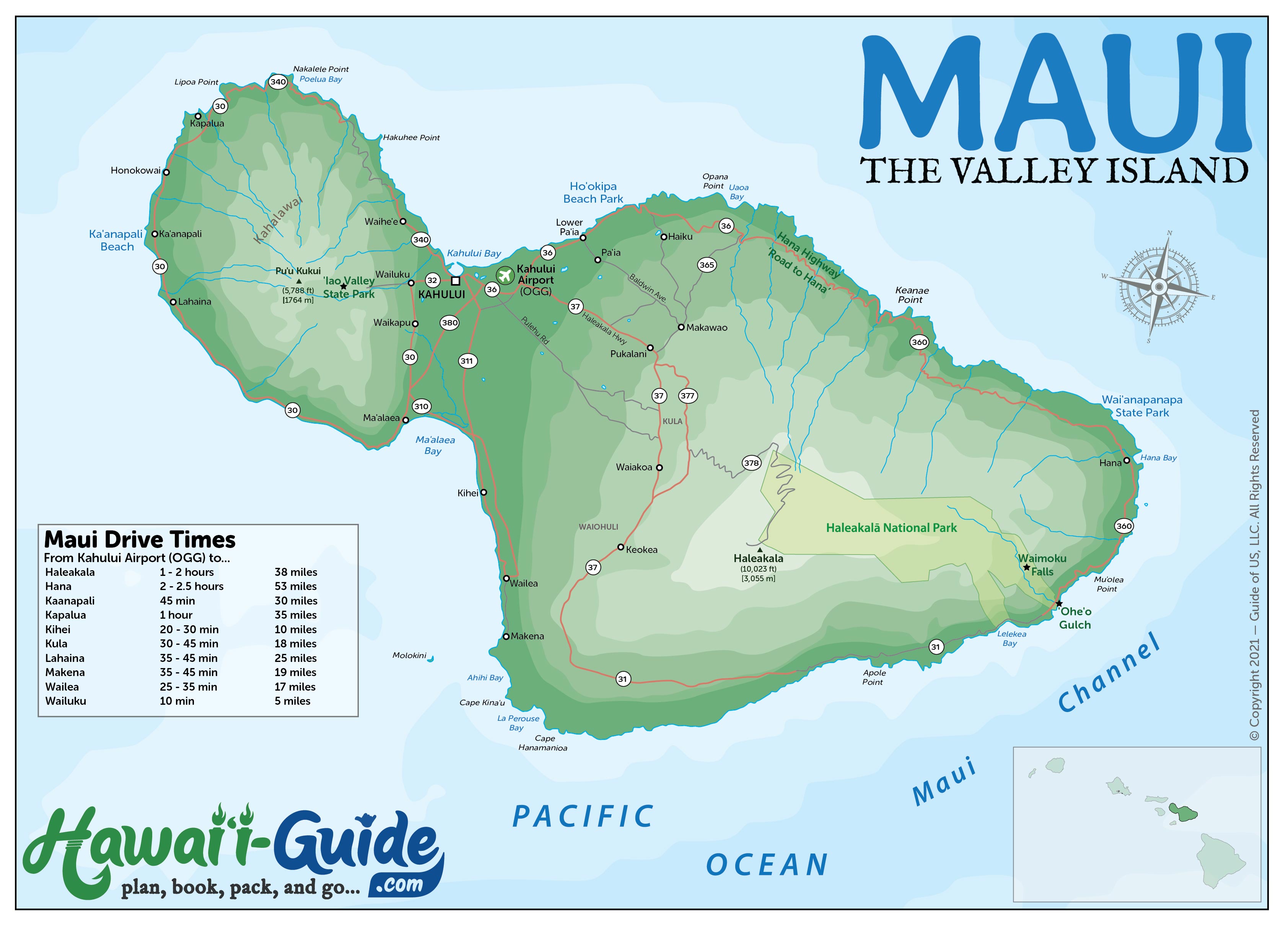
Maui Driving Times Between Destinations
Maui isn't huge, but winding coastal roads and mountain passes can make 30 miles feel like an hour. These are realistic driving times without traffic or stops.
| From | To | Distance | Drive Time |
|---|---|---|---|
| Kahului Airport (OGG) | Ka'anapali / West Maui | 25 mi | 45-50 min |
| Kahului Airport (OGG) | Kihei / South Maui | 12 mi | 20-25 min |
| Kahului Airport (OGG) | Wailea / Makena | 17 mi | 30-35 min |
| Kahului Airport (OGG) | Kapalua / Northwest Maui | 32 mi | 55-60 min |
| Kahului | Hana (Road to Hana) | 52 mi | 2.5-3 hrs |
| Kahului | Haleakala Summit | 36 mi | 1.5-2 hrs |
| Ka'anapali | Kihei / Wailea | 24 mi | 40-50 min |
| Ka'anapali | Hana | 77 mi | 3-3.5 hrs |
| Hana | 'Ohe'o Gulch (Seven Sacred Pools) | 10 mi | 20-25 min |
A few notes: the Road to Hana time assumes no stops — realistically, budget a full day with stops (10-12 hours round trip). The drive to Haleakala summit is slow going above 6,000 feet due to switchbacks. Traffic on the Honoapiilani Highway between Central and West Maui can add 15-30 minutes during morning and evening rush.
Updated Maui Travel Map Packet + Guidesheet
Updated with a new high-resolution map of Maui. Includes most major attractions, all major routes, airports, and a chart with estimated Maui driving times.
PDF packet now additionally includes both a Maui Beaches Map + our Road to Hana Map.
Our included 2026 Maui Summary Guidesheet consists of the top must-see & do attractions, best times to visit, where to stay briefing, airport detail, a monthly weather summary, and where to find the most noteworthy local ono 'grindz' (best eats) on Maui.
-File is formatted as a print-ready PDF document
Printable Free Maui Hawaii Maps
Click any map to view full size or download for offline use.