11-02-2024
Haleakala & Upcountry Maui Itinerary
Upcountry Maui Gardens, Haleakala National Park Summit, and Overlooks

Founder & certified Hawaii travel expert with 20+ years of experience in Hawaii tourism.
Aloha! This article may link to trusted Hawaii resources at no extra cost to you. Mahalo for your support!

Haleakala & Upcountry Maui in a Day
A Wayfinders Guide to Upcountry Maui, Haleakala National Park, and nearby Overlooks
Today's Maui itinerary explores the incredible sights, attractions, and hiking trails of Haleakala & Upcountry Maui, on the eastern side of Maui. The term Upcountry Maui refers to the towns, ranches, vineyards, parks, farmlands, and visitor attractions on the upper slopes of Haleakala volcano, including Haleakala National Park. Enchanting and rural, Maui's Upcountry is the heart of the island's agricultural industry, as well as a thriving artists' community.
Many compare the beautiful landscape of Upcountry Maui to the countryside in Scotland. Discover several unique floral gardens in this part of Maui. Plus, find some of the best views of the South Pacific from the high elevations of the upcountry.
Of course, we highly recommend exploring Haleakala National Park. Haleakala National Park makes up the entire central portion of East Maui- describing it as "impressive" would do it a great injustice. Spanning across a vast swath of Maui's eastern region, Haleakala is home to the highest peak on Maui, at 10,023 feet. It also holds the world record for a road climbing to the highest elevation in the shortest distance- a mere 38 miles!
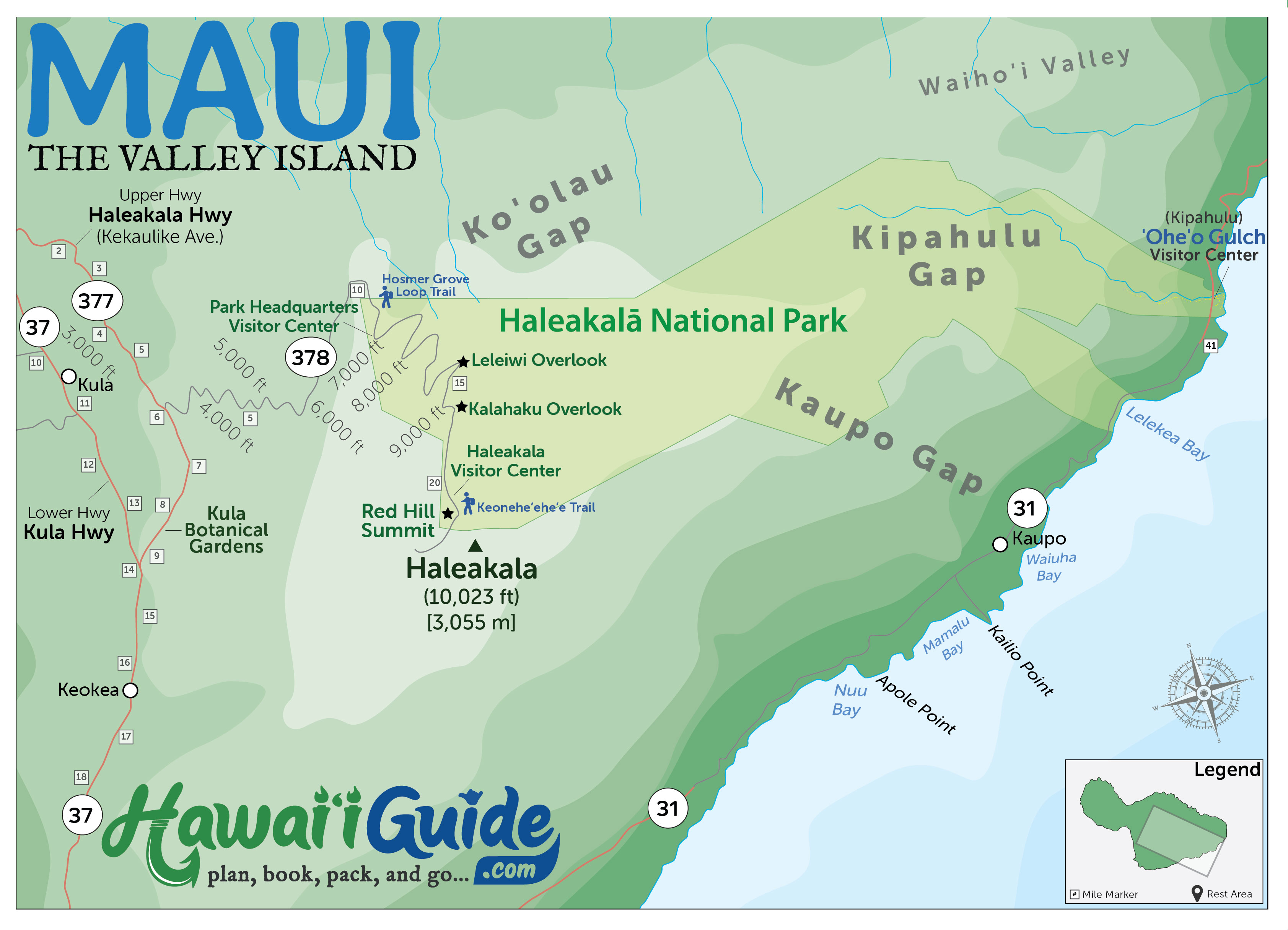
Haleakala & Upcountry Maui Map
We’ve provided all Maui directions via Google Maps when possible, as Google Maps works on all platforms and across all devices. You should be able to pop the directions into your phone or tablet and go.
To help you visualize each day’s itinerary, we’ve also provided a Haleakala & Upcountry Maui overview map that helps you get your bearings.
Haleakala & Upcountry Maui Itinerary Stops
Itinerary for Healakala & Upcountry Maui...
Get Your Free Maui Guide
Instant access — opens immediately
- Beaches, activities & top spots
- Restaurant & dining recommendations
- Maps, itineraries & insider tips
Want the full offline version? Get the Complete Maui Guidebook →
Stop # 1.) Hosmer Grove
Hosmer Grove Loop Trail
We'll kick off our Haleakala & Upcountry Maui itinerary by suggesting a Hosmer Grove Loop Trail visit. You can find it immediately inside the park.
Quick Pro Tip: Your entrance fee ticket covers the Kipahulu area of Haleakala National Park in east Maui and the Pi'ilani Highway of the park for up to three days. So save your admission stub if you plan to visit the Kipahulu area later in your trip.
Hosmer Grove Loop Trail
Haleakala's summit area and its barren moon-like landscape are a real treat for the senses. Before exploring the barren summit region, let's enjoy the lush trees and vegetation along the Hosmer Grove Loop Trail. As you trek the trail, notice the cedar, spruce, pine, eucalyptus, etc.
Hosmer Grove Trail is located (just barely) inside Haleakala National Park. Find it near the mile marker 10.5 on Highway 378. After entering the park, you'll want to turn left to the start of the Hosmer Grove trail.
Hosmer Grove Trail is a half-mile-long nature trail that winds through a very intriguing forest of trees not native to Hawaii. in 1910; Ralph Hosmer planted these trees and other groves of trees: eucalyptus from Australia, sugi pine from Japan, deodar from India, Douglas fir, and several species of pine from mainland US, and more. The grove presents a perpetual struggle between native plants and introduced Hawaiian islands species.
Brochures found at the beginning of the trail will guide you along the grove. They labeled most of the trees found along the forest. Or print a copy of the brochure and map from the NPS Hosmer Grove Brochure.
Stop # 2.) Haleakala Overlooks
Leleiwi Overlook and Kalahaku Overlook
After exploring Hosmer Grove, return to Hwy 378. Next, begin the climb to the summit of Haleakala. At about 7,000ft elevation, you'll find the Park Headquarters Visitor Center- the first stop to the peak. The Center holds pertinent park information, permits, interpretative program, and flush toilets. Continue ahead to reach another visitor center where views are significantly more impressive.
Leleiwi Overlook
Haleakala's beauty is simple to spot. It's all around you! However, there are several proverbial hidden gems in the summit area. One of the best is the Leleiwi Overlook.
The elevation here is around 8,800 ft. The overlook provides a panoramic view of the vast crater of Haleakala. This gigantic depression spreads 7.5 miles long (east to west), 2.5 miles wide, and 3,000 ft. deep. The entire island of Manhattan could fit inside the massive crater.
The view from the crate lies exceptionally close to the moon. In the past, NASA used this area to view the moon. The astronauts who landed on the moon trained here.
To reach this destination, pull into the parking lot from the right side of the road. Just come up from Hwy 378, at mile marker 17.5, inside Haleakala National Park. Many folks bypass this location because it appears unnoticeable. Don't make that mistake!
Kalahaku Overlook
Don't miss the Kalahaku overlook. The overlook provides a picture-perfect bird's-eye view of Haleakala's crater floor and a rare silversword plant.
The Leleiwi Overlook, at approximately mile marker 18.7 on Highway 378, provides a superb view of the crater floor. From the rim's overlook, at 9,324 ft., all the hikers trekking below seem minuscule.
Its observation deck has plaques that explain the different volcanic formations here. You can find a great place to observe the Koolau Gap and Kaupo Gap from the deck.
Stop # 3.) Haleakala Summit
Haleakala Summit Visitor Center, Red Hill, and Keoneheehee (Sliding Sands) Trail
After checking out the two scenic overlooks, you can ascend to the summit of Haleakala. As you ascend to its summit, discover why everyone calls Haleakala the 'House of the Sun.' Along your way, stop at the summit's Visitor Center. To find it, take the road leading to the path to the 'Red Hill.' Another way includes taking a stroll from the Visitor Center's parking along the Sliding Sands Trail. It also leads to Haleakala. Appreciate the size of this volcano as you hike into the crater.

Haleakala Summit Visitor Center
The Haleakala Visitor Center is a small stone building perched right at the edge of a cliff. The Center sits at Mile Marker 20.5, at 9,740ft. Since 1936, the Center opened itself to park visitors. Park staff begin their shift from sunrise to 3 pm daily. They assist park visitors with planning their Haleakala visit and answer questions. Ask about any interpretive programs that they often offer.
Just a few steps from the Visitor Center, you'll find the Pa Kaoao Trail. It leads to a 100 ft. (30 m.) overlook with a remarkable view. Be sure to trudge up the 0.4 mi. (0.6 km) trail, as the change in altitude is very noticeable!
Pu'u Ulaula Summit (Red Hill)
After leaving the Haleakala National Park Visitor Center, turn left out of the visitor center parking lot. At mile marker 21, you'll come to another intersection. Take a right to reach the parking lot for the summit. Note that the left road takes you to Science City and the observatories. Yet, they are off-limits (kapu) to the public. They build the summit parking lot in the shallow crater of Puu Ulaula (Red Hill).
Climb the steps to the shelter or take the more gradual ramp from the far end of the parking lot. From the southeast, you can see Mauna Loa and Mauna Kea's high summits on the Big Island. Each summit stands over 13,000 feet in elevation.
Haleakala's highest point, Pu'u Ulaula Summit, offers extraordinary 360-degree views of Haleakala's breathtaking landscape. Plus, it's one of the best places for stargazing, enjoying the sunset, and watching the clouds change before your eyes.
While there, look for the rare Hawaii silversword that grows here. Silverswords take up to 50 years to bloom and then die. Many consider this viewing as a unique opportunity.
Keoneheehee (Sliding Sands) Trail
After leaving the summit of Haleakala, head back down to the Visitor Center. On the opposite end of the parking lot, you'll find the trailhead of Keoneheehee (Sliding Sands) Trail. The trail is a starting point for a stroll or a strenuous 3-day backpacking trip. For this itinerary, we'll stick to the more stroll option. We recommend dressing warmly since the summit of Haleakala stands at an elevation near 10,000ft. It can get chilly. The trail starts at the bulletin board by the Haleakala Visitor Center parking lot entrance.
Be sure to prepare yourself for jaw-dropping views into the Haleakala volcano. It may look big from the summit lookout, but to appreciate just how BIG this volcano is, you'll want to hike down into it a bit. Go as far as you feel comfortable because it will be some physical work to get back out. The elevation loss/gain is pretty consistent, so it won't be too lousy hiking out if you only hike the first half or full mile in. Overall, the trail descends 2,800 ft. in the first 4 miles to the valley floor, but you probably don't want to hike that far as it becomes pretty strenuous. Instead, on an excellent half-day (and yet still moderately strenuous) hike, we recommend the first 2.5 miles of the trail to the Ka Lu'u o ka O'o cinder cone before turning around and taking the route back out. The round trip is a 5-mile trek, and given the elevation, it'll feel like it's longer. The last climb back up Haleakala's crater rim will also take a day. Total elevation gain/loss between the trailhead and the cinder cone is approximately 1,400 ft.
Be sure to stay on the trail. It limits any damage to the rare and native Silverswords that grow near and around the course. The contrasts of colors as you go along the path are incredible. The Aerial-like landscape is pretty amazing to view in person—photos don't do it justice.
Stop # 4.) Optional - Botanical Garden in Kula
Kula Botanical Garden
The next three-stop(s) are optional if time or energy allows. You may opt to stay at the summit and watch the incredible sunrise unfold before you -the colors often rival other famous lights. Consider the following optional stops, like two gardens, if you have any spare time.
Kula Botanical Garden
About half a mile beyond the 8-mile marker, on Highway 377, you'll find the Kula Botanical Garden on the mauka (toward the mountain) side of the road. Kula Botanical Garden houses nearly 2,000 indigenous Hawaiian flora and fauna species.
The showy protea reigns supreme. Established in 1968 by Warren and Helen McCord, the garden displays Warren's landscape architecture business. Today, the garden serves as a tourist destination that draws thousands of visitors every year.
The garden is on the slopes of Haleakala. It encompasses 8 acres of colorful and unique plants, amazing rock formations, a covered bridge, waterfalls, koi pond, aviary, and extra attractions like the carved tiki exhibit. Kula Botanical Garden houses hundreds of plants for you to enjoy and photograph. The garden includes a collection of native Hawaiian plants. Children especially will enjoy the Jackson Chameleon exhibit, Nene geese, African Cranes, and aviary.
Stop #5.) Optional - Witness an Upcountry Sunset
Sun Yat Sen Park
If none of the other options suit you, consider watching the sunset from Sun Yat Set Sen Park. The park sits further down Highway 37, near the Enchanting Floral Garden stop.
Sun Yat Sen Memorial Park
Sun Yat-Sen Memorial Park is a small roadside park in Keokea makai (toward the ocean) between miles 18 and 19 on Highway 37. It is about 2,400 feet above the south Maui coast, and the scenic views here are excellent.
From this location, you can get some spectacular scenic views, including an excellent view of the surrounding Hawaiian Islands offshore: Kaho'olawe (the larger one to the left), uninhabited after decades of use as a bombing range and Molokini (the smaller one in front of Kaho'olawe), a semi-circular island. Its deep cove is a trendy snorkeling spot. Off to your left, near the shoreline, is the Pu'u Ola'i cinder cone in Makena State Park. Directly ahead of you on the horizon is Lana'i and to your right are the West Maui Mountains, likely draped in clouds. One last great thing about this vantage point is the incredible sunsets. If you are lucky enough to be at this location late in the day before the sun sets, you will get a color show, unlike anything you've ever seen.
How Our Maui Itineraries Work
Remember, each of our Maui Day-By-Day Itineraries serves as a grab-and-go resource for 'mapping' your trip. Mixed, shuffled, and re-ordered our itineraries according to your desires for this dream vacation. As fellow travelers, we understand the value of having options. Subsequently, consider our plans as suggestions that you can ultimately adapt to your liking. For instance, if one of our suggested stops or Maui attractions doesn't sound appealing to you, skip to the following suggested stop on the list.
Mapping Your Maui Trip
We've designed our itineraries around a set number of on-island Maui days: one, two, three, four, five, six, and seven-day itineraries. Our well-planned itinerary will help you explore the island, soak in the best sights, and ensure your precious time on Maui. We split our itineraries between those seeking adventure and those seeking to relax. Overall, we designated this to build your dream Maui trip.
Haleakala & Upcountry Maui Final Suggestions & Thoughts
May you find our expert travel tips resourceful for planning your trip to Haleakala & Upcountry. To support your endeavors, we covered all of the significant features of this region. Get ready to have a great time exploring this portion of Maui.
Remember, each of our Maui Day-By-Day Itineraries is used as a grab-and-go resource for 'mapping' your trip. We provide daily itineraries for mixing, shuffling, and re-ordering them according to your taste. Please don't feel obligated to do everything listed on our daily itineraries. We mean them as suggestions. Ultimately, only select the options you find most favorable.
Maui Itineraries
Published by: John C. Derrick
Founder & certified Hawaii travel expert with 20+ years of experience in Hawaii tourism.
Affiliate Disclosure: We may earn commissions from some travel partners (like Amazon or Expedia) which helps us maintain this site. These links are at no extra cost to you and don't impact our honest & unbiased recommendations. Remove all the ads →
×
![]()
Try out our AI Powered
Search & Chatbot →
Get Your Free Hawaii Visitor Guide
Enter your email and we'll send you instant access to our free 2026 Hawaii Starter Guide + Summary Guidesheets.