We may earn a commission when you book or buy through links on this page.
Christ Memorial Episcopal Church
Located within the North Region on Kauai
Christ Memorial Episcopal Church
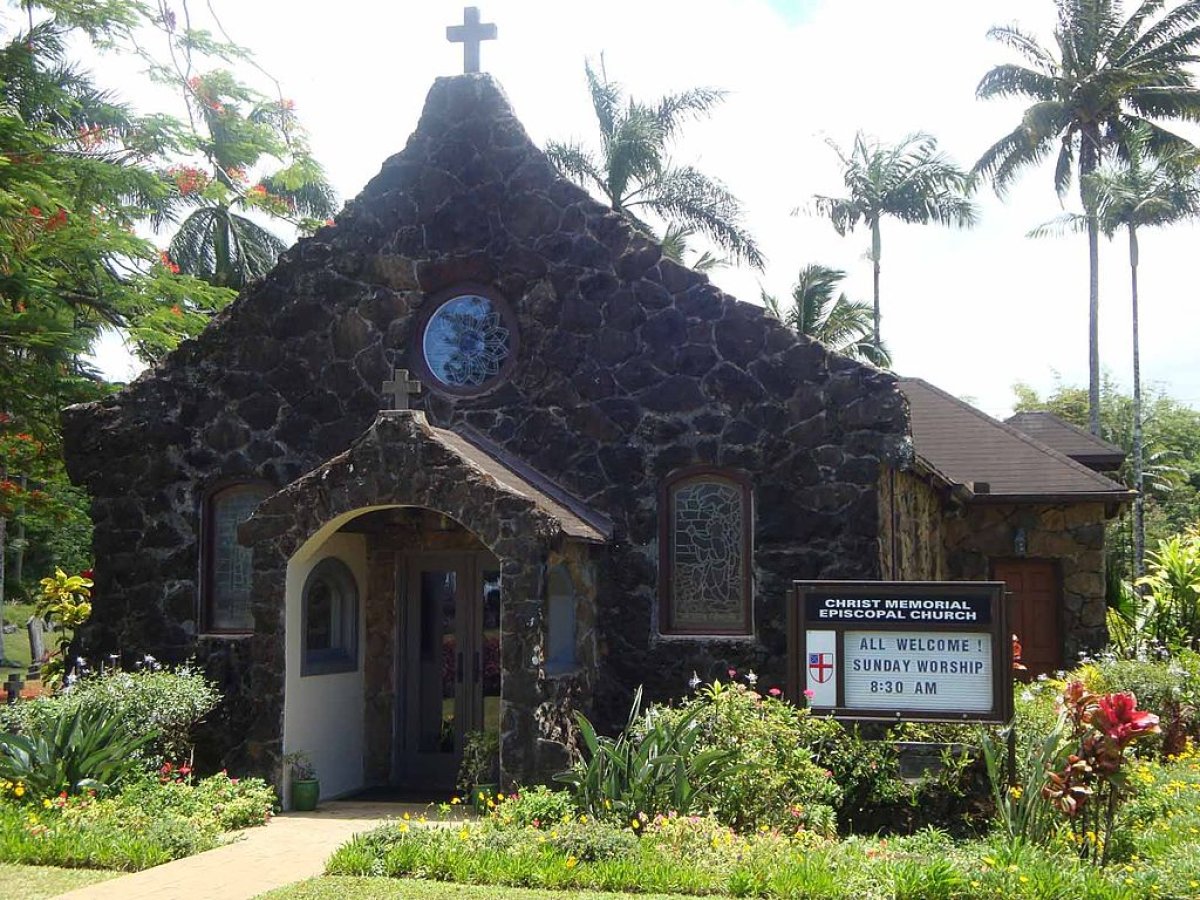
Christ Memorial Episcopal Church is a small lava-rock chapel on Kolo Road in Kilauea, on Kauai's north shore, consecrated in 1941. The Kilauea Sugar Company donated both the stone and the land it sits on, which ties the little church directly to the town's plantation roots.
The Stained Glass
The windows are the reason to slow down here. The stained glass was made in England and has since been restored. The detail holds up to a close look, even if you only view the chapel from outside.
The Churchyard
Walk the small cemetery beside the chapel before you leave. Some of the headstones are more than 100 years old. It is a quiet spot, and a five-minute wander says more about old Kilauea than any plaque.
A Working Church
This is an active congregation, not a museum piece. Regular Sunday worship services are held here, and the congregation often allows non-members to hold weddings in the chapel.
Getting There
Take Highway 56 north from Anahola toward Kilauea. Just past mile marker 23, turn right onto Kolo Road. The church comes up just before the next left, Kilauea Road. If you are headed to Kilauea Lighthouse, you will pass right by it — the lighthouse route turns left onto Kilauea Road at the church.
Explore smarter
Turn this stop into a better day plan.
Use maps, timing, access checks, and current conditions before adding another stop to the route.
Founder & certified Hawai'i travel expert with 20+ years in Hawai'i tourism, University of South Carolina climate-research training, and NOAA weather-station experience.
Mostly dry this morning with light to moderate trade winds, a few showers over windward and mountain slopes. Winds weaken and turn south tonight into Wednesday as a low-pressure system develops north of the islands, starting a wet stretch.
Wednesday afternoon through Friday, rain increases across the island, heaviest on south-facing slopes and coasts. Isolated thunderstorms are possible Wednesday night into Thursday. Rain timing and intensity depend on where the rainband sets up. No flood watch is in place yet, but conditions will be wet. Saturday and Sunday clear out as normal trade winds return.
Beach and water activities work best today and early Wednesday; plan indoor time for Wednesday through Friday as rain increases. Save hiking and summit drives for the weekend.
0:000:52
Voice
Read the transcript
Mostly dry right now with light to moderate trade winds. South-facing shores have elevated surf near advisory levels through tonight.
Winds weaken and shift south starting tonight into Wednesday as a low-pressure system develops north of the islands. Wednesday afternoon through Friday, showers and rain increase across Maui, heaviest on south-facing slopes and coasts. Isolated thunderstorms are possible Wednesday night into Thursday. Rain intensity and timing remain uncertain depending on where a rainband sets up—conditions will stay wet and may limit activity.
Saturday into Sunday, normal trade winds return and rain clears. Beach and water activities work best today and early Wednesday; plan indoor time for the wet stretch ahead. Hiking and summit trips are better suited for the weekend.
0:000:44
Voice
Read the transcript
Mostly dry this morning with light to moderate trade winds. Windward and mountain slopes have a few scattered showers.
Winds weaken and turn southerly tonight into Wednesday, and rain increases Wednesday through Friday across the island—heaviest on south-facing slopes and coasts. Isolated thunderstorms are possible Wednesday night into Thursday. Timing and intensity depend on exactly where the rain sets up and how long it lingers. Saturday and Sunday clear out and trade winds return to normal.
Get your beach time in today and early Wednesday morning. Plan indoor activities for the wet stretch, and save hiking and summit drives for Saturday.
0:000:53
Voice
Read the transcript
Mostly dry right now with light to moderate trade winds. Windward and mountain areas have a few scattered showers, but south-facing shores have elevated surf near advisory levels through tonight.
Starting Wednesday, winds weaken and turn south as a low-pressure system develops north of the islands. Rain will increase, heaviest on south-facing slopes and coasts. Isolated thunderstorms are possible Wednesday night into Thursday. Rain intensity and timing are uncertain—it depends on where a rainband sets up and how long it lingers. Saturday and Sunday, normal trade winds return and rain clears out.
Beach and water activities work best today and early Wednesday. Move indoor or covered plans to Wednesday through Friday as rain picks up. Save hiking and summit drives for the weekend.
Created with AI from the official NWS forecast discussion · verify with NWS before heading out