Project Myna · Road Trip Audio Guide
Chain of Craters Road
A one-way 18.3-mile descent inside Hawaiʻi Volcanoes National Park, dropping 3,700 feet from the summit of Kīlauea to the coast. Pit craters, rift-zone lava fields, a pali descent with 2,000-foot drops, ancient petroglyphs, and a sea arch at the dead end where lava buried the road in the mid-2000s. ~17 curated segments.
18.3 miles
16 curated segments
Free AI-narrated tour
We may link to trusted Hawaiʻi resources at no extra cost to you.
Guide Mode — Coming Soon
We're building free audio tours for Chain of Craters Road, the Road to Hana, and other iconic Hawaiian drives. Check back when they land, or head to our Chain of Craters Road guide for the full written version.
-
Intro
Intro
Show transcript
Chain of Craters Road is 18.3 miles one-way from the top of Kīlauea down to the sea. The road drops 3,700 feet — summit to shoreline. No gas, no food, no cell service past the summit, so fuel up in Volcano Village before you enter the park. The road is a dead end. Lava buried the lower section in the mid-2000s, and the park set a turnaround at a ranger station near the sea arch. You drive down, you stop at pullouts, you walk on lava, you drive back out the way you came. Plan two to three hours if you stop at most of the pullouts. Reset your car odometer at the junction with Crater Rim Drive — the park's own mile markers drift slightly and the stops in this guide are keyed to your true odometer. This whole drive sits inside the national park, so the park entry fee applies. The guide will announce each stop as it comes up. -
HAVOMILE0.4
First of four pit craters in the opening 1.5 miles. Covers the pit-crater primer and previews Puhimau (0.9), thermal hotspot (1.3), and Koʻokoʻolau (1.5) so the driver doesn't need a separate trigger for each.
Approach Cue (~12-15 sec)Show transcript
Lua Manu Crater coming up on the right in about a quarter mile. Good first stop to get your eye tuned in — Chain of Craters is named for a reason, and in the first two miles you'll pass four pit craters in quick succession. Small turnout. You can see the crater floor from the rail.Arrival Narration (~45-60 sec)Show transcript
This is Lua Manu, a pit crater about 109 yards across. A pit crater forms when magma drains out from underneath a surface area and the roof collapses — you're looking down into the space where the magma used to be. In 1974 a new flow came through here and poured into the bottom of Lua Manu, which is why the floor is a flat black pahoehoe sheet rather than a forested sink. Over the next mile of driving you'll pass three more craters in rapid sequence: Puhimau at 0.9 on the left, a thermal hotspot at 1.3 (you can sometimes feel warm ground bleed through the road surface), and Koʻokoʻolau at 1.5 on your right. Koʻokoʻolau is the anomaly in the group — no lava has touched it in over 200 years, and the forest has grown back inside the crater. Worth noticing the age contrast: raw basalt in Lua Manu, mature ʻōhiʻa and koa in Koʻokoʻolau, same kind of hole in the ground, wildly different pace of recovery. Back on the road, the Hilina Pali junction is the next stop. -
 HAVOMILE2
Side-trip stop. User explicitly wants it included because the lookout is genuinely good, but framed honestly as a 30-minute detour each way.
Approach Cue (~12-15 sec)Show transcript
Hilina Pali Road coming up on the mauka side — right-hand turn at the Y. This is an optional side trip. The detour is 8.2 miles of narrow, bumpy one-lane pavement that dead-ends at a cliff lookout. About 30 minutes each way. If you're short on time or nervous about one-lane roads, skip it. If you have the time, it's one of the better overlooks in the park.Arrival Narration (~45-60 sec)Show transcript
Hilina Pali Road runs 8.2 miles through the edge of the Kaʻū Desert, past the old Kīpuka Nēnē campground (closed for nesting), and ends at a pavilion perched on top of a 2,000-foot sea cliff. The view is end-of-the-world stuff — raw lava slopes dropping straight to the ocean, wind hard enough to make you brace your legs. In 1975 a magnitude 7.2 earthquake knocked loose a section of pali below here, and the collapse triggered a tsunami that killed two campers at Halapē on the coast. Small plaque in their memory at the lookout. The drive back up is easier than the drive down because you're no longer stopping. If you decide to skip the side trip, stay straight on Chain of Craters and Devil's Throat is coming up in about two-tenths of a mile. -
HAVOMILE2.2
Small roadside pullout, unfenced 150×165 ft pit. Arrival narration previews Hiʻiaka (MM 2.5) and Pauahi (MM 3.1) so those don't need their own triggers.
Approach Cue (~12-15 sec)Show transcript
Devil's Throat coming up on the right in about a quarter mile. Small roadside pullout — easy to miss. Park on the shoulder and walk across the road to a dirt path. Walk carefully. The path ends at the edge of a 165-foot pit with no guardrails and crumbling edges.Arrival Narration (~45-60 sec)Show transcript
Devil's Throat is a 150-foot-wide, 165-foot-deep pit right at the side of the road. Same kind of formation as Lua Manu back at the start — a collapse pit where magma drained and the ground fell in — but steeper, narrower, and terrifyingly unfenced. The name earns itself. Stay back from the lip. The edges aren't stable and there's nothing between you and the bottom except air. Just down the road you'll pass Hiʻiaka Crater at mile 2.5 and Pauahi Crater at 3.1. Pauahi is the massive one, 1,800 feet long, with a boardwalk for a proper view. This entire stretch sits on top of Kīlauea's East Rift Zone, which is why the craters line up like beads on a string: each one marks a spot where magma pushed up, collapsed, or drained back down. You're driving on a live rift. Mauna Ulu is coming up next at mile 3.6. -
 HAVOMILE3.6
Spur road off the main drive, half a mile to a parking lot with restrooms. Hike to Puʻu Huluhulu is 1 mi one-way, legitimately interesting. Full Nāpau trail requires a permit.
Approach Cue (~12-15 sec)Show transcript
Mauna Ulu turnoff coming up on the left in about a quarter mile. Short spur road, about half a mile to a parking lot with a restroom. One of the better stops on the drive if you have time — the Puʻu Huluhulu hike is short, genuinely interesting, and gives you a real sense of what fresh lava fields look like up close.Arrival Narration (~45-60 sec)Show transcript
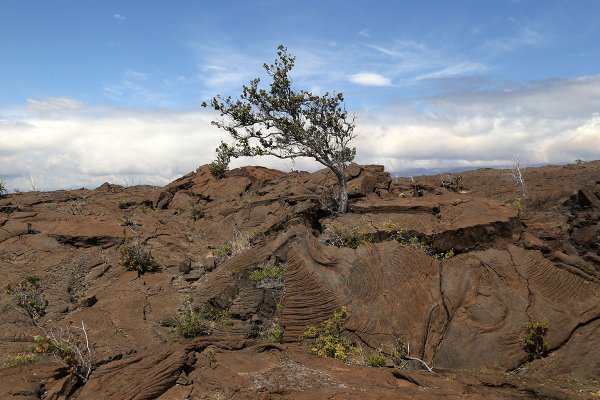
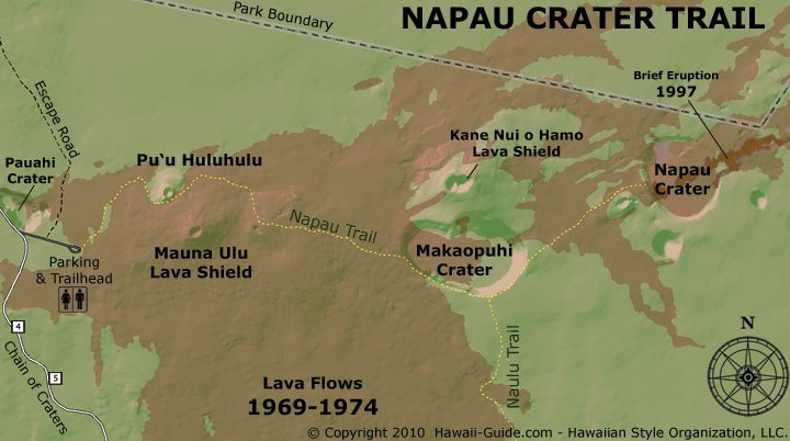
You're standing at the trailhead for Mauna Ulu, the site of Kīlauea's second-longest flank eruption in recorded history. Between 1969 and 1974 this vent built a 400-foot-tall shield of lava and sent flows all the way down to the coast, burying six miles of the old Chain of Craters Road. The full Nāpau Crater Trail is seven miles and requires a permit, but the first mile is open and doable — it takes you to Puʻu Huluhulu, a small cinder cone wrapped in vegetation. The walk crosses jagged aʻā and smooth pahoehoe from the '74 flows, threads past kīpukas (pockets of forest the lava went around instead of through), and ends at an observation point on top of the cone. On clear days you can see Puʻu ʻŌʻō to the east, the vent that drove Kīlauea's 35-year eruption cycle starting in 1983. Follow the reflective markers — the trail isn't always obvious on a black field. Pack water. There's no shade. When you come back to the car, Mau Loa O Mauna Ulu is the next stop, about two and a half miles down the road. -
Connector · HAVO
Mauna Ulu to Mau Loa Connector
Show transcript
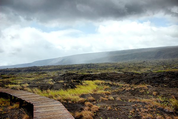
The driving between here and Mau Loa O Mauna Ulu is all through the '69–'74 Mauna Ulu flows. You're rolling across what used to be forest — the road cuts a narrow black ribbon through a frozen sea of pahoehoe. Good stretch to just quietly take it in. Notice how the lava surface shifts: ropy and twisted in places where the flow was still moving under a cooling skin, then smooth sheets where it spread out and set. A few dead ʻōhiʻa trunks stick up through the field — those are lava trees, formed when a flow wrapped around a trunk, the wood burned out, and the lava cast kept its shape. Everything you're looking at arrived here in living memory. -
HAVOMILE6.2
Roadside pullout overlooking the 1969–74 pahoehoe field. Also the trailhead for the Keauhou Trail (8 mi to the coast, most visitors skip it).
Approach Cue (~12-15 sec)Show transcript
Mau Loa O Mauna Ulu pullout coming up on the right in about a quarter mile. Easy roadside stop. You're looking across a sprawling pahoehoe field from the '69–'74 eruption we just drove through. Also the trailhead for the Keauhou Trail.Arrival Narration (~45-60 sec)Show transcript
The view off the pullout is a long black sheet of pahoehoe running to the horizon. Everything you can see came from Mauna Ulu between 1969 and 1974 — the same eruption whose vent we just left at mile 3.6. For context on scale: the Mauna Ulu eruption put out about 460 million cubic yards of lava over those five years. That's roughly 150 Great Pyramids of Giza, spread thin across the rift zone. The Keauhou Trail starts here and runs eight miles down to the coast at Keauhou Camp, which is a backcountry site with no water. Most visitors skip the hike and just look. Back on the road, the next stop is Kealakomo at mile 9.6, where the descent down the pali to the coast starts. The road is flat for now, but that changes in about three miles. -
Connector · HAVO
Mau Loa to Kealakomo Connector
Show transcript
You're about to start the pali descent, which is the most dramatic part of the drive. Pali is the Hawaiian word for cliff, and this one drops about 2,000 feet from where you're driving now down to the shoreline. The road cuts across the face of Hōlei Pali in a series of long switchbacks. As you approach Kealakomo the forest thins and the view opens up — you'll see the coast spread out below you, ocean to the horizon. Drive the descent slowly. The grade is steeper than it looks and there's almost no shoulder. You don't want to be the person tailgating a rental car that has just realized it's on a cliff. -
 HAVOMILE9.6
Wooden pavilion perched 2,000 ft above the sea at the top of Hōlei Pali. Handicapped-accessible. The pali descent starts seriously after this point.
Approach Cue (~12-15 sec)Show transcript
Kealakomo Overlook coming up on the mauka side in about a half mile. Wooden pavilion on the right, easy to spot — it's perched right on the edge of the pali. Handicapped-accessible. Pull in.Arrival Narration (~45-60 sec)Show transcript
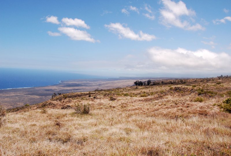
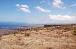
Kealakomo sits 2,000 feet above the sea on the edge of Hōlei Pali. The pavilion looks inviting, but the wind up here is strong enough to knock you off balance — a better place to lose your lunch than eat it. Directly below, under all that black lava, is where the Hawaiian village of Kealakomo used to sit. A 1971 flow wiped it out. This is also where the Naulu Trail starts if you're looking at a long day-hike option; it connects up to the Nāpau Crater Trail and the old unmaintained Kalapana trail. For most visitors, ten minutes at the pavilion is plenty. Take in the scale of the pali face — that lava poured down here in actual visible waves, frozen mid- motion. Back on the road, you're about to start the real descent. The hairpin turn at mile 11.5 catches people off guard, so take it slowly. -
Connector · HAVO
Kealakomo to Alanui Kahiko Connector
Show transcript
You're descending Hōlei Pali now. The hairpin at mile 11.5 is sharp, so slow down well before you reach it. By mile 12 you've dropped to about 1,000 feet. The road gets close to the ocean and the landscape dries out noticeably. You're rolling past pullouts with coastal views; if you see a steam plume offshore and the park alerts say lava is flowing, that's where lava is entering the ocean. Most of the time there's no active flow and the view is just blue water hitting black lava cliffs. Alanui Kahiko pullout is coming up at mile 13.7 — that's where the old road shows through. -
 HAVOMILE13.7
Arrival narration covers both the Alanui Kahiko pullout (MM 13.7 — buried old road) and Hōlei Pali lookout (MM 14.4 — cliff-face view) as one beat. Those two pullouts are close enough that a second GPS trigger would clutter the playback.
Approach Cue (~12-15 sec)Show transcript
Alanui Kahiko pullout coming up on the left in about a quarter mile. Small shoulder parking. The beat here is history underfoot — you can see the old Chain of Craters Road where lava covered it in 1972. Half a mile further at Hōlei Pali lookout (mile 14.4), you get the full cliff-face view.Arrival Narration (~45-60 sec)Show transcript
Alanui Kahiko means "old road" in Hawaiian. You're standing next to the path of the original Chain of Craters Road, which ran along this stretch of coast before the 1972 Alae Lava Shield flow buried it. If you look carefully at the black pahoehoe near the pullout you can see sections of old asphalt peeking through — flattened, cracked, half-swallowed, but unmistakably road. A good visual reminder that the park isn't a museum. It's a place where the ground keeps moving and infrastructure has a half-life. Half a mile down the road at Hōlei Pali lookout (mile 14.4), pull over again for the full cliff view: you can see how the lava came down the pali in huge swaths, the flow lines still visible frozen into the surface. From there the road is flat and coastal the rest of the way. Puʻuloa Petroglyphs is coming up at mile 15.9. -
Connector · HAVO
Alanui Kahiko to Puʻuloa Connector
Show transcript
Short drive. You're on the coastal bench now — flat ground between the pali and the ocean, all of it relatively young lava from various flows in the last few hundred years. Watch for nēnē on or near the road. They're the state bird, endangered, and they have poor traffic sense. Petroglyph trailhead is just ahead on the right. -
 HAVOMILE15.9
15,000–20,000 ancient Hawaiian stone carvings. 0.7-mile loop trail, boardwalk at the main site. Piko holes are the most common image. Vog risk at dusk.
Approach Cue (~12-15 sec)Show transcript
Puʻuloa Petroglyph Field trailhead coming up on the right in about a quarter mile. Pullouts on both sides of the road, small park sign. The walk is a 0.7-mile loop on a well-marked trail over rolling lava. Plan about 45 minutes round trip if you linger at the boardwalk.Arrival Narration (~45-60 sec)Show transcript
The Big Island has the highest concentration of ancient Hawaiian stone carvings in the state, and Puʻuloa is the densest field on the island. Estimates run between 15,000 and 20,000 individual petroglyphs. The trail crosses a rolling pahoehoe field marked with cairns, and the final approach is a boardwalk that protects the carvings while you walk above them. The most common image is a small circle with a dot in the middle — these are piko holes, and Hawaiian families would travel here to deposit a piece of a newborn's umbilical cord in the hole as a prayer for long life. The word puʻu-loa means "long life hill." You'll also see human figures, canoes, dots, straight lines, sail shapes. Do not touch the carvings. Do not make rubbings. The rock is fragile and every visit compounds the wear. Stay on the boardwalk. If you're visiting in the evening, vog (volcanic smog) can settle here and the air gets a sulfuric metallic edge; skip the walk if you're pregnant or have heart or lung conditions. Back on the road, the end of the road is coming up in about two and a half miles. -
Connector · HAVO
Puʻuloa to Sea Arch Connector
Show transcript
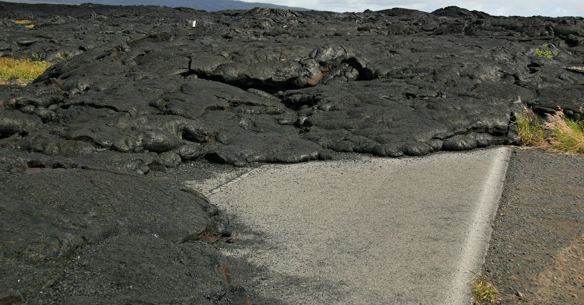
You're driving the last stretch now. The road runs along the coast with ocean on your right and young lava fields on your left. You may see fresh-looking cracks in the pavement from recent ground settlement — the coastal bench is still moving. The park ends the drive at a ranger station near the sea arch, and that's the turnaround. Pit toilet there, sometimes a small canteen. The "end of the road" is a literal statement — the pavement stops because the lava covered it. -
 HAVOMILE18.3
End-of-road stop. No active lava right now (as of April 2026), but the real draw is walking out on the mid-2000s pahoehoe flow that buried the road. User explicitly called this out as the signature experience at this stop.
Approach Cue (~12-15 sec)Show transcript
End of the road coming up in about a half mile. Ranger station, pit toilets, parking on both sides. Once you pass the barricade, walk right for the sea arch viewpoint. The pahoehoe flow that ended the road in the mid-2000s is just past the barricade — you can walk out onto it.Arrival Narration (~45-60 sec)Show transcript
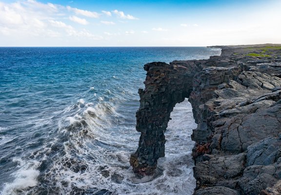
You're at the end of Chain of Craters Road. Short walk from the parking area to the sea arch viewpoint on your right. Hōlei Sea Arch sits about 90 feet off the shore, formed where the surf undercut a lava shelf until it carved itself into an arch. It's actively eroding and will eventually collapse — no timeline on that, but it isn't a permanent feature. The more interesting thing most people skip is the lava walk. Once you pass the ranger barricade on foot, you're walking on the pahoehoe flows that buried the old road in the mid-2000s — a series of flows from the Puʻu ʻŌʻō eruption that covered the lower portion of this road and continued all the way into the ocean. No active lava right now, but you can walk out onto the hardened flow surface and get a real sense of what it looks like when a road disappears under rock. Rope lines and signage — obey them. Silvery-blue ropy textures, cracks, pressure ridges, the occasional lava tree cast. A geology lab you can walk on. Stay on marked paths, watch your footing (pahoehoe edges are sharp and unstable), and keep back from any steam cracks. When you've seen enough, head back to the car. The drive out takes about 45 minutes without stops. -
Outro
Outro
Show transcript
You're headed back to the summit now. The return drive is quicker because you've already seen the pullouts, but the light will be different — afternoon sun on the pali you just descended, shadows long across the rift zone, maybe the summit caldera steaming more visibly as the day cools. When you hit the junction with Crater Rim Drive, options open up. Kīlauea Iki trailhead is right there if you still have energy for a hike. The summit caldera overlooks, the old Jaggar Museum site, the Thurston Lava Tube are all within a few miles. You've seen about 2 percent of Hawaiʻi Volcanoes National Park today. That's not a bad day's work.
AI-narrated audio synthesized by ElevenLabs, voiced by Hoku (feminine) and Honu (masculine). Hoku and Honu are Voice Library donors, not native Hawaiian speakers. Some pronunciations may land slightly off — mahalo for your patience as we refine.
Try out our AI Powered
Search & Chatbot →
Get Your Free Hawaii Visitor Guide
Enter your email and we'll send you instant access to our free 2026 Hawaii Starter Guide + Summary Guidesheets.