12-04-2022

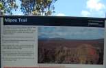
Napau Crater Trail
Located within the Volcano Region on Big Island

President & certified Hawaii travel expert with 15+ years of experience in Hawaii tourism.
Aloha! This article may link to trusted Hawaii resources at no extra cost to you. Mahalo for your support!
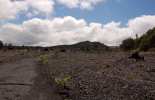
After passing Pauahi crater on Chain of Craters Road, look for a spur road to the left at Mile Marker 3.6. Follow it about half a mile to a parking lot with a restroom. At the end of the road there is a path that leads to the Napau Crater Trailhead. The entire trail is over seven miles long and requires a permit. However, the first leg, a little over a mile will take you to Pu’u Huluhulu, a tree-draped cinder cone. This area is the site of Kilauea’s second longest flank eruption in known history.
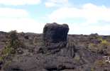
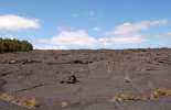
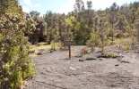
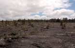
The trail zig zags through a field of jagged a’a and smooth pahoehoe lava from 1974 flows. The path is fairly well worn but make sure to follow the small reflective trail makers set out on the lava. Take a moment to observe this varied landscape. There will be small groupings of trees and plant life that seem to spring out of nowhere amidst a field of pitch black lava. These areas, called kipukas, are parcels of land that by luck were spared from the lava flows. Several lava trees and massive lava bombs also dot the trail.
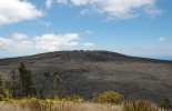
After about a mile of trekking across lava (follow the cairns; or stacks of rocks), you will reach Pu’u Huluhulu, which is literally translated “hairy hill” because of the wealth of vegetation that has overgrown the crater. The trail snakes up the side of the crater in a series of switchbacks eventually leading to an observation area. When Pu'u O'o was erupting, from 1984-2018, you could see it from this location.
From the top of Pu’u Huluhulu you can also see Mauna Ulu to your right which flooded this area with lava from 1969-1974. From the bottom of the crater, the Napau Trail continues on to Napau Crater and Camp.
The journey to Napau is seven miles one way over wild and fascinating landscape. The trail skirts around the mouth of Makaopuhi Crater and eventually ends at Napau Camp which has neither water nor shelter. Rangers recommend a stock of at least three quarts of water per day for the hike.
A camping permit can be obtained from the Kilauea Visitor Center.
Published by: Tori C. Derrick
President & certified Hawaii travel expert with 15+ years of experience in Hawaii tourism.
Napau Crater Trail Reviews
Guidereview:
B (based on 11 visitor reviews)Geolocation Data
Geographic Coordinates
Latitude: 19.36478425
Longitude: -155.2146279
Hawaii Safety Information
Location
multiple_stop
Length
Approximately 2 miles round-trip to Pu'u Huluhulu; longer if you explore beyond
bathtub
Facilities
Pit toilet at trailhead
flash_on
Hazards
Hike is over old lava flows, prepare accordingly
my_location
Nearby
Located within Hawaii Volcanoes National Park
alarm
Duration
1-3 hours depending on how much you explore.
terrain
Difficulty
Mostly easy; follow the cairns (stacks of rocks)
Napau Crater Trail Photo Gallery


Recommended Tours Nearby
Affiliate Disclosure: We may earn commissions from some travel partners (like Amazon or Expedia) which helps us maintain this site. These links are at no extra cost to you and don't impact our honest & unbiased recommendations. Remove all the ads →
×
![]()
Try out our AI Powered
Search & Chatbot →