07-25-2022

Laupahoehoe Point
Located within the North Hamakua Region on Big Island

President & certified Hawaii travel expert with 15+ years of experience in Hawaii tourism.
Aloha! This article may link to trusted Hawaii resources at no extra cost to you. Mahalo for your support!
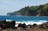
Between the 28 and 27 mile markers turn makai onto Laupahoehoe Point Road. As you twist and turn through the thick jungle neighborhood and eventually reach the point where the ocean beats the shore, you will begin to understand the beauty that drew the people to this area.
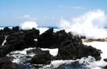
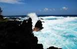
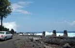
However, it was nature's force that claimed the lives of twenty-one children and three adults during the April Fools Day Tsunami of 1946. The terrifying power of the ocean simply swept everything out of this area. Now, people live a respectful distance from the unpredictable sea. A monument stands to honor those who perished. Survivors of the tsunami from Laupahoehoe and other parts of the island share their stories through video and displays at the Pacific Tsunami Museum in Hilo. There is also a park here with a pavilion, safe drinking water, and a boat ramp. The surf pounds this rocky coastline with great fury which is impressive to watch, but do not swim here.
Published by: Tori C. Derrick
President & certified Hawaii travel expert with 15+ years of experience in Hawaii tourism.
Laupahoehoe Point Reviews
Guidereview:
A (based on 56 visitor reviews)Geolocation Data
Geographic Coordinates
Latitude: 19.99293217
Longitude: -155.2406208
Hawaii Safety Information
Laupahoehoe Point Photo Gallery


Recommended Tours Nearby
Affiliate Disclosure: We may earn commissions from some travel partners (like Amazon or Expedia) which helps us maintain this site. These links are at no extra cost to you and don't impact our honest & unbiased recommendations. Remove all the ads →
×
![]()
Try out our AI Powered
Search & Chatbot →