
Historic Noteworthy Events at Kilauea Volcano
Click any link below to learn more...
- December 2024 - Periodically Ongoing Eruption - lava returns to Halemaumau crater at the summit
- September 2024 Eruption - brief after dark eruption in remote HVNP area.
- June 2024 Eruption - A new eruption began north of the Koa'e fault system and Hilina Pali Road
- September 2023 Eruption - Fountains of lava return to the summit crater
- June 2023 Eruption - Lava returned to Halemaumau crater
- January - March 2023 Eruption - Eruption activity resumed within Halemaumau
- 2021-2022 Eruption - additional summit activity in Halemaumau
- 2020-2021 Eruption - Lava returned to Halemaumau
- 2019 Eruption - Lava Lake Developed in Halemaumau Crater
- 2018 Eruption - Significant event in the East Rift Zone
- Previous Historic Eruptions
This section will be updated accordingly.
Eruption returns in Halemaumau Crater
December 2024 - March 2026 Eruptions
For ongoing updates to the current eruption, see our Eruption Updates page.
Eruption History/Timeline
Episode I
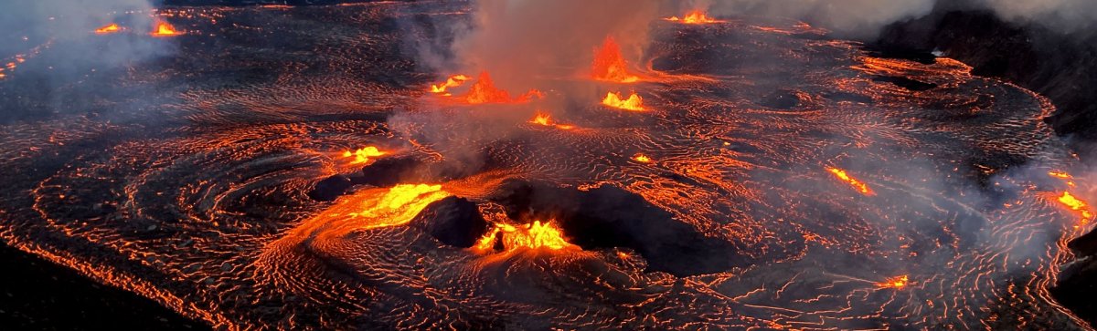
The eruption within Halemaumau Crater (view USGS Eruption GIF here) began at approximately 2:20 a.m. on Monday, December 23, 2024, and vents erupted on the floor of the southwest part of the summit caldera.
At 4:30 a.m., lava fountains were observeEd with heights up to 80 meters (262 feet). Molten material, including lava bombs, was being ejected from the vents on the caldera floor up onto the west caldera rim, within the closed area of Hawaiʻi Volcanoes National Park. The volcanic gas and ejecta hazards west of the erupting vents stress the hazardous nature of this closed area of Kīlauea's summit. By 5:30 a.m., lava covered an estimated area of 400 acres of the caldera floor.
Eruptive activity is currently confined to the summit region. No significant changes have been observed in the rift zones.
Around 3 p.m. on the eruption day, the summit's tilt stopped showing deflation, and seismic tremors began decreasing. By 3:30 p.m., lava fountains were barely visible. By 4 p.m., the fountaining had stopped, and seismic tremor was close to background levels. Visible volcanic gas emissions have also decreased significantly. These observations indicate that the eruption has slowed considerably and appears to be entering a pause.
Episode II
The eruption at Kīlauea volcano that began on Monday, December 23, continued the morning of December 25, 2024. The eruption had been relatively stable over the past day, following the resumption of activity that occurred yesterday morning. Vigorous lava fountains remain active in the western portion of Halema‘uma‘u crater, sending lava flows across the crater floor. Eruptive activity remains confined to Halemaʻumaʻu and the downdropped block within the caldera and may fluctuate in vigor over the coming days.
Episode 2 of the December 2024 summit eruption of Kīlauea paused just before 11:00 a.m. on Christmas Day.
The vigorous fountaining from vents in the southwest corner of Halemaʻmaʻu crater rapidly died down over a few minutes just before 11:00 a.m. Lava began draining back into the vent at 11:00 a.m. at nearly the same time summit tiltmeters began recording a change from deflation to inflation. Seismic tremors also decreased markedly at the same time. The pattern was similar but more abrupt than the pause onset on Monday, December 23, between 3 and 4 p.m.
Episode 2 lasted a little over 24 hours, about twice the duration of the first eruptive episode. Prior summit eruptions have lasted days to weeks, and there is a high probability that this eruption will resume if the summit repressurizes in the coming days.
Episode III
Around 6 p.m. on December 27, 2024, the eruption transitioned from low level lava flows to the onset of more vigorous fountaining.
Lava began erupting from vents around 8 a.m. yesterday morning (December 26) marking the beginning of the third phase of the ongoing summit eruption. Sluggish lava flows continued to erupt from the northern vents for the next day and a half. This was much longer than the 3-4 hours of sluggish eruption that preceded the fountaining of the second episode. Current fountain is occurring bursts up to 30-45 ft (10-15 m) high from the two most northern vents. If fountaining continues, it is possible that the fountain heights will increase as more gas-rich lava erupted. It is not possible to estimate how high the fountains may get or how long the fountaining will last, but prior episodes have produced fountains over 200 feet high (70 m) that last up to 24 hours.
The eruption within Halemaʻumaʻu crater paused at approximately 8:40 p.m. on January 3, 2025, with both fountaining and lava flow effusion ceasing at the same time. Currently there is no lava draining back into the southern vent, which was the only vent actively erupting at the time.
Episode IV
Around 9:15 a.m. HST on January 15, 2025, the eruption of Kīlauea within Kaluapele (summit caldera) resumed with a small lava flow exiting the north vent, following low-level continuous lava spattering that started around 5:40 a.m. HST. from the same vent. Around 9:55 a.m., low-level lava fountaining started with more rigorous lava flow activity.
The small sluggish lava flow from the north vent at around 9:15 a.m. on Wednesday January 15, 2025, marks the beginning of the fourth episode of the ongoing summit eruption.
On January 18, 2025, the eruption within Kaluapele (summit caldera) paused around 10:10 a.m. H.S.T. Activity greatly decreased at approximately 9:45 a.m. the morning of January 18, 2025, when the north vent fountain and associated lava flow stopped erupting, and south vent activity greatly diminished at the same time. Lava continued to flow from south vent for another 20 minutes at a much reduced rate.
Episode V
The eruption of Kīlauea within Kaluapele (summit caldera) resumed just before 3:00 p.m. HST on January 22, 2025. This marks the beginning of the fifth episode of the current eruption that began on December 23, 2024, following the most recent pause that began on Saturday, January 18, 2025.
The summit eruption at Kīlauea volcano that began in Halemaʻumaʻu crater on December 23, 2025 ended its 5th episode at 4:30 AM HST January 23, 2025, after 26 hours of eruptive activity from the north vent. The 5th episode began at 2:30 p.m. HST January 22, 2025 and continued overnight with fountaining to 30-50 m height and Pele's hair observed at the Steaming bluff car park. The 5th episode activity was accompanied by tremor on seismometers, deflation on near vent tiltmeters and gas discharge estimated at greater than 10000 tonnes per day. The fountain activity stopped suddenly at about 4:30 AM HST along with the end of lava effusion from the vent. Seismic tremor diminished at this time and returned to pre- fountaining levels. A strong glow from the north vent indicates that magma remains close to the surface of Halemaʻumaʻu within Kaluapele (the summit caldera).
Episode VI
The eruption of Kīlauea within Halemaʻumaʻu crater resumed at 11:28 p.m. HST on January 24, 2025, when fountain-fed lava flows erupted out of the north vent.
This marks the beginning of the sixth episode of the current eruption that began on December 23, 2024, following the most recent pause that began on Thursday January 23, 2025 at 4:30 a.m. HST.
The eruption of Kīlauea within Halemaʻumaʻu crater paused at 12:36 p.m. HST on January 25, 2025, when fountain-fed lava flows stopped erupting out of the north vent.
Episode 6 began at 11:28 p.m. on January 24, 2025, and lasted for just over 13 hours.
Episode VII
Episode 7 of the ongoing Halemaʻumaʻu eruption began at 6:41 pm HST on January 27, 2025 and is currently feeding a small flow onto the crater floor.
Episode 7 was preceded by small, sporadic spatter fountains that began at approximately 1:30 p.m. and continued to increase in intensity until 6:41 p.m., when sustained fountaining began. Fountains from the north vent are 100-120 feet (30-40 meters) high and feeding multiple lava streams at 7:40 pm HST. The flow had covered 15-20% of the crater floor this time. A small fountain can be seen in the south vent and there is a small lava flow emerging from the south side of its cone at 7:35 p.m. HST on webcams.
Episode 7 of the ongoing Halemaʻumaʻu eruption ended abruptly at 10:47 a.m. HST on January 28, 2025.
The southern vent stopped erupting just after 10:43 a.m. HST followed shutdown of the north vent at 10:47 a.m. HST. Lava flows from this episode covered more than half of the floor of Halemaʻumaʻu within the southern part of Kaluapele (Kīlauea caldera).
Episode VIII
Kīlauea eruption paused at 7:23 p.m. HST, February 4, 2025. Episode 8 of the ongoing summit eruption in Hawai'i Volcanoes National Park has ended.
Episode 8 lasted approximately 21.5 hours. Lava flows and fountains stopped erupting from the north vent at about 7:07 p.m., followed by the south vent at 7:23 p.m. Lava flows from episode 8 covered greater than half of the Halema'uma'u crater floor.
Episode 8 of the ongoing Halemaʻumaʻu eruption began at 9:52 p.m. HST on Monday, 3 February 2025 and is fountaining from the north vent.
Episode 8 was preceded by small, sporadic spatter fountains that began on Sunday evening, February 2, 2025, which began to increase in intensity in the afternoon on February 3, 2025 until 9:52 p.m., when sustained fountaining began. Fountains from the north vent have grown from 50 ft (15m) to over 250 ft (80 m) high in an hour and are feeding multiple lava streams at 10:50 p.m. HST. Active lava flows now cover approximately 15-20% of the crater floor.
Episode IX
Kīlauea stopped erupting the morning of February 12, 2025, in Hawaiʻi Volcanoes National Park. Episode 9 of the ongoing summit eruption paused at 8:43 a.m. HST.
This was the ninth episode of Kīlauea's ongoing eruption in Halemaʻumaʻu crater within Kaluapele (the summit caldera) that began on December 23, 2024. Fountain-fed lava flows from the north and south vents erupted onto the crater floor for over 22 hours. There have been nine episodes of lava fountaining separated by pauses in activity. All recent eruptive activity has occurred in Hawaiʻi Volcanoes National Park. No significant changes have been noted along Kīlauea’s East or Southwest Rift Zone.
Episode 9 of the ongoing Halemaʻumaʻu eruption began the morning of February 11, 2025, at 10:16 a.m. HST, with lava fountains producing a lava flow on the Halemaʻumaʻu crater floor.
Episode 9 was preceded by small, sporadic spatter fountains that began early yesterday (February 10, 2025) morning and increased in intensity overnight. Fountains from the north vent are estimated to be roughly 330 feet (100 meters) high at 10:45 a.m. and covering about a quarter of the Halemaʻumaʻu crater floor. Slow effusion of lava at the south vent began at approximately 10:50 a.m.
Episode X
Episode 10 of the ongoing Halemaʻumaʻu eruption ended at 9:18 a.m. HST on February 20, 2025, after just under 13 hours of fountaining.
Episode 10 of the ongoing Halemaʻumaʻu eruption began at 8:22 p.m. HST on February 19, 2025, with low-level fountaining within Halema'uma'u Caldera.
Fountains from the north vent are 300-400 feet (90-125 meters) high and feeding multiple lava streams between 8:22 and 9:05 p.m. HST. Less than 10% of Halemaʻumaʻu is currently covered with lava flows as of 8:45 p.m.
Episode XI
Episode 11 of the Kīlauea summit eruption paused at 7:06 a.m. HST on February 26, 2025, within Hawai'i Volcanoes National Park after erupting for 12 hours and 44 minutes.
Episode 11 of the ongoing Halemaʻumaʻu eruption began at 6:26 p.m. HST on February 25, 2025, within Hawaiʻi Volcanoes National Park. The eruption began with low-intensity spatter with lava erupting onto the caldera floor through a spillway in the north vent. The intensity and height of fountaining have continued to escalate since the eruption began reaching heights of over 200 feet (60 m) by 6:50 p.m. HST. Lava flows have covered 10-15% of the floor of Halemaʻumaʻu at this time.
Episode XVII
Episode 17 of the ongoing Halemaʻumaʻu eruption ended at 9:45 a.m. HST on April 9, 2025 when low fountaining at the south vent stopped. Fountains from the south vent sustained heights of 50-200 feet (15-60 meters). Overall, episode 17 lasted 35.5 hours and consisted of sustained fountains from the south vent and minor north vent activity that stopped around 11:15 a.m. HST on April 8, 2025.
Episode 17 of the ongoing Halemaʻumaʻu eruption began at 10:15 p.m. HST on April 7, 2025 with the start of lava overflowing from the south vent.
Episode 17 was preceded by a glow from the south vent that increased at about 9:20 p.m. HST on April 7, indicating the gradual rise of lava in the vent prior to the start of the eruption. Lava continues to overflow the vent, spreading across the floor of Halema'uma'u, and is being fed by low spatter fountains 15-30 feet high (5-10 meters) as of 2:50 a.m. HST on April 8. Each of the prior 16 episodes ultimately involved significant lava fountaining, with the fountains of episode 16 exceeding 1,000 feet (305 meters) in height. High lava fountains will likely follow the current low fountaining and lava flows.
Episode XVI
Episode 16 of the ongoing Halemaʻumaʻu eruption ended at 12:03 p.m. HST on April 2, 2025, when the high fountaining at the south vent stopped. Fountains from the south vent sustained heights of 600-700 feet (180-210 meters) for over 23 hours, then dropped to less than 300 feet (90 meters) at 9:50 a.m. HST this morning, April 2, 2025. Overall, episode 16 lasted just over 37 hours, with the last 25 hours and 39 minutes consisting of fountains from the south vent.
During episode 16, lava flows covered over 50% of the floor of Halemaʻumaʻu within the southern part of Kaluapele (Kīlauea caldera). Weak winds also resulted in Pele's hair and tephra deposition in closed areas of Hawai'i Volcanoes National Park and on Highway 11 between mile markers 35 and 37 on April 1, 2025.
The high fountain phase of episode 16 of the ongoing Halemaʻumaʻu eruption began at 10:24 a.m. HST on April 1, 2025, about 12 hours after the start of the episode. Fountaining from the south vent rapidly increased to over 200 feet (70 meters) in height by 10:40 a.m. HST and exceeded 700 feet (215 m) by 10:50 a.m. HST. Low dome fountaining and overflows continue from the north vent.
Episode 16 of the ongoing Halemaʻumaʻu eruption began at 10:57 p.m. HST on March 31, 2025, with the start of lava overflowing from the north vent.
Episode 16 was preceded by weak spattering in the north vent that began at approximately 5:20 p.m. HST on March 31, 2025. Since 6:00 p.m. HST, spattering became continuous and increased to low fountaining (15-30 feet or 5-10 meters high). Lava level gradually rose in the vent and is now overflowing out of the north vent cone onto the floor of Halemaʻumaʻu. Each of the prior 15 episodes ultimately involved significant lava fountaining, with the fountains of episode 15 exceeding 1,000 feet (305 meters) in height. High lava fountains are likely to follow the current dome fountaining and lava flows within 24 hours or less.
Episode XV
Episode 15 of the ongoing Halemaʻumaʻu eruption ended at 7:10 p.m. HST on March 26, 2025, when the fountaining at the south vent stopped. North vent fountains had ceased activity earlier, around 12:00 p.m. HST. Overall, episode 15 lasted just over 31 hours with the last 9 hours consisting of high fountains predominantly from the south vent.
Initial activity from episode 15 included cycles of gas pistoning for roughly 24 hours, followed by fountains from both vents. The transition to high fountains began just after 10:00 a.m. HST today, with early fountain heights growing rapidly in the first 30 minutes to greater than 600 feet (180 meters) high. Later, fountaining reached maximum heights of over 1,000 feet (305 meters).
Episode 15 of the ongoing Halemaʻumaʻu eruption began at 12:04 p.m. HST on March 25, 2025, with cyclic lava spatter and flows, followed by the onset of sustained high fountains from both the north and south vents at 10:20 a.m. HST March 26, 2025. Currently fountains are in excess of 600 feet (180 meters) high.
Episode 15 fountaining was preceded by over 100 cycles of lava rise and fall, vent overflows, and spatter fountains in the north vent, a phenomenon known as 'gas pistoning', which has been observed in other eruptions at Kīlauea in recent decades.
Episode XIV
Episode 14 of the ongoing Halemaʻumaʻu eruption ended at 1:49 p.m. HST on March 20, 2025, when fountaining at the south vent stopped. Fountains from the north vent ceased 11 minutes earlier.
Lava flows from this episode covered about 75% of the floor of Halemaʻumaʻu within the southern part of Kaluapele (Kīlauea caldera). Episode 14 lasted 28 hours and 23 minutes with the last 7 hours and 19 minutes consisting of fountains up to 600 feet (180 meters) high predominantly from the south vent.
---
Prior to Episode 14 of the ongoing Halemaʻumaʻu eruption, six small, short-lived lava flows erupted between midnight and 6:00 a.m. HST. on March 19, 2025.
Small, short-lived, sluggish lava flows began overflowing the south vent just before midnight. The first flow was active from 23:58 p.m. HST March 18, 2025 to 00:02 a.m. HST March 19, 2025 and the second from 00:56 to 1:03 a.m. HST. These were followed by a third tongue of lava from the south vent from 1:57 to 2:01 a.m. HST and a fourth from 3:36 to 3:46 a.m. HST. The fifth and sixth sluggish lobes erupted from 4:20 a.m. to 4:28 a.m. HST and 5:04 to 5:14 a.m. HST. None of the flows lasted more than 10 minutes nor went more than about 50 feet (15 meters) from the south vent. Occasional spatter bursts could be seen in the north vent on the V1 camera throughout the night and becoming more frequent in the early morning hours. The small overflows from the south vent and observed spattering in the north vent show that magma is very near the surface in both vents.
Episode XIII
Episode 13 of the ongoing Halemaʻumaʻu eruption ended at 3:13 p.m. HST on March 11, 2025.The north vent ceased fountaining abruptly at 3:11 p.m. HST. Subsequently, the south fountain became unsteady and also ceased activity by 3:13 p.m. HST. Episode 13 fountaining lasted for 12 hours and 37 minutes, and lava flows have covered more than 60% of Halemaʻumaʻu crater floor.
Each episode of Halemaʻumaʻu lava fountaining since December 23, 2024, has continued for 13 hours to 8 days, and episodes have been separated by pauses in eruptive activity lasting less than 24 hours to 12 days.
Episode 13 of the ongoing Halema'uma'u eruption began at 2:36 a.m. HST on March 10, 2025.Fountains reached heights of 400-500 feet (120-150 m) by 3:30 a.m.
Episode 13 was preceded by small, sporadic spatter fountains 15-30 feet high (5-10 m) that began at approximately 1:30 p.m. HST on March 10, 2025, within the north vent and continued to increase in intensity until 6:35 p.m. HST when spattering could be seen on the streaming webcam (V1). Spattering continued to increase during the night and into the early morning hours of March 11. Lava erupted from the north vent at 2:36 a.m. HST and high fountains began about 10 minutes later. Fountains from the north vent are now 400-500 feet (120-150 meters) by 3:30 a.m. HST. Lava flows from the north vent have covered 20-30% of Halema'uma'u crater floor.
Episode XII
Episode 12 of the Halemaʻumaʻu eruption of Kīlauea within Hawaiʻi Volcanoes National Park ended at 10:37 a.m. HST on March 5, 2025, after just under 22 hours of continuous eruptive activity. Fountaining from the south vent ceased at 10:35 a.m. when summit deflation changed to inflation and tremor decreased.
Episode 12 of the ongoing Halemaʻumaʻu eruption began at 7:30 a.m. HST on March 4, 2025, with sporadic small lava flows alternating between the south and north cones. The transition to continuous fountaining started at 2 p.m. HST.
The first-morning lava flow came from the south vent and lasted approximately 20 minutes. It was followed by another sluggish flow from the north vent at 9:33 a.m. HST that lasted about 12 minutes. Small fountains within the south vent fed a third small flow beginning at about 12:45 p.m. HST, which continued until 2:00 p.m. HST when fountaining started at the north vent. Fountains from the north vent were within the north cone and about 20-30 feet (5-10 meters) high at the start. By 2:20 p.m., HST fountains reached 150-165 feet (45-50 m).
From this point, the order is from most recent to oldest....
Episode XLIII
Episode 43 of lava fountaining in Halemaʻumaʻu began at the summit of Kīlauea at 9:17 a.m. HST on March 10, 2026.
Lava fountaining from the north and south vents stopped at approximately 6:21 p.m. HST on March 10, 2026. Episode 43 ended after 9 hours and 4 minutes. Lava fountaining reached a maximum height of 1,300 feet (400 meters), with all activity confined to Halemaʻumaʻu crater. An estimated 16 million cubic yards (12 million cubic meters) of lava erupted and covered about 50% of the crater floor. The total erupted volume since December 2024 is now close to 325 million cubic yards (250 million cubic meters).
-Episode XXVIII-
Episode 28 of the ongoing Halemaʻumaʻu eruption began at 4:10 a.m. HST on July 9, 2025, and is currently exhibiting a vent overflow and fountains reaching roughly 150 feet (45 meters).
Episode 28 of the ongoing Halemaʻumaʻu eruption ended abruptly at 1:20 p.m. HST on July 9, 2025, after 9 hours of continuous fountaining, the final 8 of which were high fountaining.
Episode XXVII
Episode 27 of the ongoing Halemaʻumaʻu eruption ended abruptly at 7:54 p.m. HST on June 29, 2025, after nearly 11 hours of continuous fountaining.
Episode 27 of the ongoing Halemaʻumaʻu eruption began at 9:05 a.m. HST on June 29, 2025, when ongoing lava fountains from the north vent became more vigorous. These fountains are now reaching heights of about 500 feet (150 meters) and feeding multiple lava streams that are flowing onto the crater floor.
Episode XXVI
Episode 26 of the ongoing Halemaʻumaʻu eruption ended abruptly at 10:25 a.m. HST on Friday, June 20, 2025, when lava fountains and flows stopped erupting from the south vent. The episode consisted of about 8 hours of continuous lava fountaining.
Episode 26 of the ongoing Halemaʻumaʻu eruption began at approximately 1:40 a.m. HST on June 20, 2025, with lava fountains and flows erupting from the north vent. Lava fountains are currently reaching heights of over 1,000 feet (300 meters).
Episode XXV
Episode 25 of the ongoing Halemaʻumaʻu eruption ended at 8:08 p.m. HST on June 11, 2025, after about 8 hours of continuous fountaining.
Episode 25 of the ongoing Halemaʻumaʻu eruption began at 11:57 a.m. HST on June 11, 2025, and the volume and vigor of lava fountains and flows has increased markedly as of 12:30 p.m. Lava is currently fountaining from the north vent, reaching heights of approximately 330 feet (100 meters).
Episode 25 was preceded by intermittent gas-pistoning in the north vent, with associated small spatter fountains and lava flows which began before dawn on June 10. This activity, which occurred at a rate of about 5-10 gas piston events per hour, continued to increase in intensity until 11:57 a.m. on June 11, when a small sustained dome fountain began to feed lava flows onto the crater floor. As of 12:30 p.m. HST, fountains from the north vent are reaching about 165 feet (50 meters) high and feeding multiple lava streams.
Episode XXIV
Episode 24 of the ongoing Halemaʻumaʻu eruption ended abruptly at 4:28 a.m. HST on June 5.
The north vent stopped erupting at approximately 4:08 a.m. HST. The south vent stopped erupting at approximately 4:28 a.m. HST, marking the end of the episode. Lava flows from this episode on the floor of Halemaʻumaʻu within the southern part of Kaluapele (Kīlauea caldera) may continue to exhibit slow movement or incandescence as the cool and solidify over the coming days.
Episode 24 of the ongoing Halemaʻumaʻu eruption began at 8:55 PM HST on June 4 and is currently fountaining from the north vent.
Episode 24 was preceded by sporadic spatter, gas pistoning, and hydrogen flames that began on the morning of June 3. At approximately 8:55 PM HST, episode 24 began with low dome fountaining accompanied by lava flows onto the crater floor. Small sustained lava fountains, less than about 100 feet (30 meters) high, began erupting from the north vent around 9:15 PM. Activity increased again around 10:10 PM, when fountain heights increased to 325 feet (100 meters) and by 10:40 reached over 980 feet (300 meters). Additionally, the fountain generated a plume that reached 16,500 feet (5,000 meters) above ground level by 10:50 PM and is increasing.
Episode XXIII
Episode 23 of the ongoing Halemaʻumaʻu eruption ended abruptly at 10:25 p.m. HST on Sunday, May 25, 2025.
High fountains and lava flows erupted from both vents during this episode. The north vent stopped erupting at 9:48 p.m. HST. The south vent stopped erupting at approximately 10:25 p.m. HST. Lava fountains from the north vent reached heights of more than 1,000 feet (300 meters). Lava fountains from the south vent reach heights of more than 800 feet (250 meters). The eruptive plume was heavily laden with tephra (ash, scoria, and Pele's hair) and reached at least 5,000 feet (1,500 meters) in height. Lava flows from this episode covered about half of the floor of Halemaʻumaʻu crater within the southern part of Kaluapele (Kīlauea caldera).
Episode 23 of the ongoing Halemaʻumaʻu eruption began at 4:15 p.m. HST on May 25, 2025, with the onset of sustained lava fountains. Lava flows are covering the floor of Halema'uma'u crater. Activity started in the north vent, which escalated to high fountains by 4:50 p.m. The south vent followed with smaller fountains by 5:15 p.m. As of 5:20 p.m., lava fountains from the south vent are about 230 feet (70 meters) in height, while lava fountains from the north vent exceed 1,000 feet (300 meters).
Episode XXII
Episode 22 of the ongoing Halemaʻumaʻu eruption ended abruptly at 3:29 p.m. HST on May 16, 2025.
The north vent stopped erupting at 3:29 p.m. HST after 10 hours and 16 minutes of high fountains (10 hours of 46 minutes of continuous eruption). Lava flows from this episode covered about 40% of the floor of Halemaʻumaʻu within Kaluapele (Kīlauea caldera). The estimated volume of erupted lava is 3.8 million cubic meters (5 million cubic yards).
Eruption of episode 22 high fountains began at 5:13 a.m. HST on May 16, 2025. Fountains from the north vent have reached maximum heights of up to 300 meters (1000 feet).
Episode XXI
Episode 21 ended at 08:34 p.m. HST on Tuesday, May 11, 2025, after ~8 hours of sustained fountaining. The Halema'uma'u eruption is currently paused.
Episode 21 sustained lava fountaining from the north vent began at 12:45 p.m. HST on May 11, 2025. Dome fountains at the start of the new gas-piston cycle evolved into continuous lava fountains that grew rapidly in vigor and height. North vent lava fountains are 500 feet high (150 m) and are feeding lava flows covering about 10-20% of the floor of Halema'uma'u crater. The south vent is not currently active.
Episode XX
Episode 20 ended at 9:58 p.m. HST on Tuesday, May 6, 2025, after 4.5 hours of sustained fountaining. The Halema'uma'u eruption is currently paused.
Episode 20 sustained lava fountaining began at 5:28 p.m. HST on May 6, 2025, as north vent cyclic gas-pistoning transitioned to continuous eruption of lava fountains that grew rapidly in vigor and height. Fountains from the north vent quickly reached heights of greater than 500 ft (150 m). North vent lava fountains are feeding fast-moving lava flows that are covering the floor of Halema'uma'u crater, including a flow that poured over the south vent. The south vent is not showing signs of increased activity at this time.
Episode XIX
The main fountaining of episode 19 of the ongoing Halemaʻumaʻu eruption, which began at about 9:28 p.m. HST on May 1, 2025, ended at 5:20 a.m. HST on May 2 after erupting from the north vent for just under 8 hours.
Episode 19 of the ongoing Halemaʻumaʻu eruption began at about 9:28 p.m. HST on May 1, 2025 with 200-300 foot (60-100 meter) high fountains from the north vent.
Episode 19 was preceded by 26 cycles of low dome fountaining and short overflows from the north vent followed immediately by lava draining back into the vent. Each cycle of fountaining lasted for about 10–15 minutes, separated by about 10 minutes of repose. These precursory fountaining cycles began at approximately 11:49 a.m. and increased in intensity around 6:45 p.m., less than 3 hours before sustained fountaining began. Fountains from the north vent are estimated to be about 330 feet (100 meters) high with multiple lava streams flooding the southwestern portion of the crater floor.
Episode XVIII
Episode 18 of the ongoing Halemaʻumaʻu eruption ended abruptly at 1:28 p.m. HST on April 22, 2025.
Episode 18 of the ongoing Halemaʻumaʻu eruption previously resumed with lava overflowing the south vent at 3:20 a.m. HST on April 22, 2025 followed by the onset of fountaining from both vents at 3:30 a.m. HST. Lava began overflowing the north vent at 3:47 a.m. HST. Fountains are currently over 650 feet (200 meters) high at the south vent and over 160 feet (50 meters) at the north vent. Both fountains are feeding a vigorous flow on the floor of Halemaʻumaʻu crater. Lava has currently covered about over 20% of the floor of Halemaʻumaʻu crater. Strong deflation accompanied the onset of lava flows at 3:20 a.m. and tremor increased with the onset of fountaining from both vents.
The ongoing Halemaʻumaʻu eruption was previously paused. On April 20, 2025, episode 18 resumed with lava flows erupting from the south vent starting at approximately 7:45 a.m. HST with 4 cycles of flows that ended around 12:44 p.m. HST. Glow continued to be observed from the vents overnight, but there was no noticeable spattering or vent overflows after the cycles ended. Tilt continues to show inflation, and a deflationary signal could accompany lava fountaining or more small lava flows could precede the fountaining phase.
Episode 18 of the ongoing Halemaʻumaʻu eruption began at 10:01 p.m. HST on April 16, 2025 when lava started overflowing from the north vent.

December 24, 2024 Eruption - USGS

December 23, 2024 Eruption - USGS
Get Your Free Big Island Guide
Instant access — opens immediately
- Beaches, activities & top spots
- Restaurant & dining recommendations
- Maps, itineraries & insider tips
Want the full offline version? Get the Complete Big Island Guidebook →

December 2024 Eruption Map
Eruption in remote part of HVNP
September 2024 Eruption
Kilauea volcano erupted briefly just west of Napau Crater on the middle East Rift Zone. This eruption likely occurred between approximately 9:00 and 10:00 p.m. HST on Sunday 15, 2024, in a remote and closed area of Hawaiʻi Volcanoes National Park. Chain of Craters Road, which is closed, is located downslope and downwind of the new fissures.
On September 16, 2024 the eruption resumed in the middle East Rift Zone at about 6 p.m. HST. Activity continued overnight, but generally decreased.

Kilauea's middle East Rift Zone eruption - September 2024 (USGS)

USGS Map depicting eruption location in September 2024
On September 17, 2024, approximately 4 a.m. HST, activity increased and during a morning overflight at approximately 8 a.m. HST, HVO geologists observed that new vents had opened in Nāpau Crater. In total, the fissure system has stretched over 1.6 kilometers (1.0 miles) of the East Rift Zone, with lava flows now covering 18 hectares (44 acres).
On September 18, 2024, during the USGS Hawaiian Volcano Observatory morning monitoring overflight, geologists observed that the activity had greatly decreased. Only weak low fountaining within a tiny lava pond was observed at one vent.
At 3:15 p.m. HST, on September 18, 2024, new eruptive fissures opened west of Napau Crater. A monitoring camera deployed by HVO field crews with permission from Hawaiʻi Volcanoes National Park recorded “lava falls” cascading down the northwest walls of Napau Crater. Vigorous activity continued and by the morning of September 19, about 2/3 of Napau Crater floor had been covered with new lava.
As of 10 a.m. HST on September 20, 2024, eruptive activity had paused.

USGS Map depicting eruption location in September 2024
Eruption resumes in HVNP
June 2024 Eruption
A new Kilauea eruption began at approximately 12:30 a.m. HST on Monday, June 3, likely about a mile (1-2 km) south of Kilauea caldera and north of the Koa'e fault system and Hilina Pali Road, within Hawai'i Volcanoes National Park.
Glow was visible in webcam imagery, indicating that lava was erupting from fissures. The most recent eruption in this region was during December 1974, which lasted only about 6 hours.
The eruption took place in a remote location within the national park, was low in eruptive volume, and did not pose an immediate threat to human life or critical infrastructure.
The eruption occurred approximately 3 km (2 miles) southwest of Kaluapele (Kilauea caldera) within Hawai'i Volcanoes National Park. That eruption lasted less than 9 hours and generated small lava flows that covered about one third of a square mile (one half of a square kilometer).
The eruption that began southwest of Kīlauea’s summit at approximately 12:30 a.m. HST this morning, June 3, has ended.

USGS Map depicting eruption location
Eruption temporarily resumes in Halemaumau Crater
September 2023 Eruption
At approximately 3:15 p.m. HST on September 10, 2023, the USGS Hawaiian Volcano Observatory observed eruptive activity in Kilauea summit webcam images and from field reports indicating that an eruption has commenced within Halemaʻumaʻu crater and on the down-dropped block to the east in Kīlauea's summit caldera, within Hawai‘i Volcanoes National Park. The eruption was preceded by a period of strong seismicity and rapid uplift of the summit.
The eruption that began at the Kilauea summit on September 10, 2023, has ended. Lava supply to the vents on the downdropped block in Kilauea's summit caldera ceased on September 16, 2023, based on visual and geophysical observations.
We will continue to post updates above, on this page as eruption(s) continue.

September 2023 Eruption - USGS YouTube
Eruption resumes again in Halemaumau Crater
June 2023 Eruption
At approximately 4:44 a.m. HST on June 7, 2023, the USGS Hawaiian Volcano Observatory detected glow in Kilauea summit webcam images indicating that an eruption had commenced within Halema'uma'u crater in Kilauea's summit caldera, within Hawai'i Volcanoes National Park.
This summit eruption event at Kīlauea volcano ended on June 19, 2023.
Kilauea June 2023 Eruption Photos

USGS Photo of Eruption on June 7, 2023

Eruption on June 7, 2023 - USGS
Eruption resumes in Halemaumau Crater
January 2023 - March 2023 Eruption
Kilauea volcano was previously erupting. At approximately 4:34 p.m. HST on January 5, 2023, the USGS Hawaiian Volcano Observatory detected a glow in Kilauea's summit webcam images, indicating that the eruption had resumed within Halemaʻumaʻu crater in Kilauea's summit caldera, within Hawai‘i Volcanoes National Park.
This eruption concluded on March 7, 2023.
Kilauea Early 2023 Eruption Photos

Halemaumau Crater - Jan 6, 2023 at Sunrise :: Credit USGS

Lava Fountains during January 2023 Eruption :: Credit USGS

Eruption in January 2023 - Credit: USGS

Lava fills crater floor - Credit: USGS

Halemaumau in October 2021
More activity in Halemaumau Crater
September 2021 - December 2022 Eruption
The 2021-2022 eruption within Halemaumau Crater started about 20 minutes after 3 p.m. Wednesday - September 29, 2021; all lava was confined within the crater. The eruption came after a day of increased earthquake activity at the volcano and summit.
The eruption from September 2021 - December 2022 was confined to Halemaumau crater, within Hawaii Volcanoes National Park. As of December 9, 2022, Kilauea was no longer erupting. Lava supply to the Halemaʻumaʻu lava lake ceased based on lava lake levels and the behavior of the crater floor.
At the time of the last eruption, HVO did not see any indication of activity migrating elsewhere on Kilauea volcano and expects the eruption to remain confined to the summit region.
Kilauea summit eruptions over the past 200 years have lasted from less than a day to more than a decade.
The eruption slowed in early December 2022, coinciding, but likely unrelated to, the eruption of neighboring Mauna Loa. As of approximately December 9, 2022, Kilauea was no longer erupting.

View from the Keanakako'i Overlook in late 2021. Credit: NPS Photo/J.Wei

Eruption in Halemaumau Crater (Credit: USGS)

Two of the many spattering sources within Halemaumau (Credit: USGS)

September 29th 2021 Eruption at Halemaumau Crater (Credit: USGS)

Lava lake statistics through May 7, 2021 (Click for full size) - via USGS
Lava returns to Halemaumau Crater
December 2020 - May 2021 Eruption
After the huge changes that occurred with the 2018 eruption and subsequent summit collapse, some had speculated that Kilauea would not erupt for a significant period of time. Pele had other plans, however.
At approximately 9:30 p.m. HST on Sunday - December 20, 2020, the USGS Hawaiian Volcano Observatory (HVO) detected a new glow within the Halemaumau crater at the summit of Kilauea Volcano.
Within Halemaumau, an eruption had commenced at Kilauea's summit caldera. Previously, as noted below the caldera had been filling with a green-ish water lake, but that quickly disappeared, as lava has once again made an appearance inside of the crater. Within one week, what had been a history-making lake of water was replaced by a nearly 600-foot deep lake of molten lava.
- Animated GIF of eruption first occurring on December 20, 2020
A magnitude 4.4 earthquake additionally hit about an hour after the volcano began erupting. By the morning of 12/21/20, two of the three initial fissure vents on the wall of the Halemaumau crater were feeding a growing lava lake.
The eruption paused in late May 2021, after several months of activity in the Halemaumau crater.
2020-2021 Eruption Images
Halemaumau Crater at Kilauea Volcano

Credit: USGS/M. Patrick

Credit: NPS/A. LaValle

Credit: NPS/J. Wei

Credit: NPS/A. LaValle

Kilauea's Lava Lake - Credit: USGS
Development of Water Lake in 2019
On August 1, 2019, USGS Hawaiian Volcano Observatory (HVO) scientists confirmed a growing pond of water in the recently enlarged Halemumau crater. Initially, it appeared as small, separate turquoise ponds, but over time, the small ponds united and began to grow dramatically. For a period of time, the depth of the growing lake was increasing several inches per day.
In the space of just over one year's time, a persistent lake of lava had vanished in a dramatic collapse, only to be replaced by the first lake of water to be recorded at Kilauea in modern history.
Over the course of its relatively short lifespan, the lake grew to be approximately 160 feet (49 m) deep. That's taller than a 10-story building, for reference. The lake also changed color due to the precipitation of iron-sulfate minerals and SO2 being dissolved into the water.
2018 East Rift Zone Eruption
Kilauea caldera has undergone a tremendous amount of change over the last decade, and prior to the eruption in December 2020, had not been very active since 2018. See the maps immediately below to get an idea of how volatile the years between 2009 and 2018 were at the park or explore this geo-narrative by the USGS about the 2018 eruption.
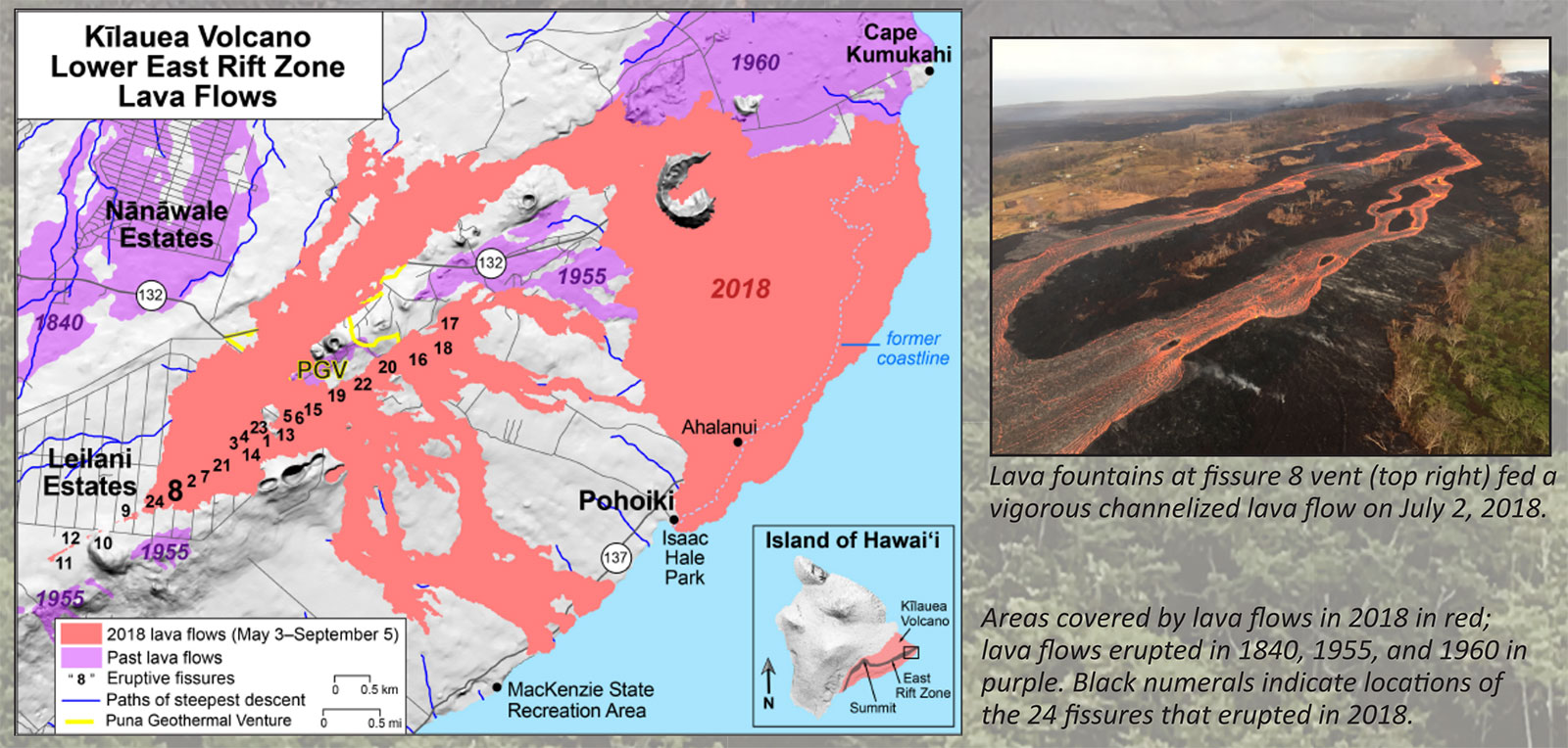
In the first days of May 2018, the lava lake that had existed in Halemaumau crater for almost a decade began to drain away. Magma moved from the summit of Kilauea to the Lower East Rift Zone, marked by a series of earthquakes. On May 3rd, the first fissures opened up in the subdivision of Leilani Estates and the massive eruption of 2018 began to unfold in lower Puna.
With less magma left to support the summit, the Halemaumau crater began to collapse. Every 28 hours, on average, the ground within the summit caldera of Kilauea sank with dramatic collapse events. By the end of the 2018 eruption, the Halemaumau crater had sunk by 1,600 feet (488m), and its diameter more than doubled.

Halemaumau Crater Changes from 2009 to 2018. Provided by the USGS.
2018 Eruption - Source: USGS
Activity circa 2018 East Rift Zone Eruption
Prior to 2018, you could just as easily have witnessed lava flows chewing on Chain of Craters Road as you could view a steam plume from afar. Kilauea is a living, breathing volcano with a mind of its own.
Kilauea's oldest lava flows are dated between 210,000 and 280,000 years ago. Those flows are considered generally young, geologically speaking, for an active volcano.
For the last one thousand years, Kilauea's ongoing eruptions have dramatically shaped the southeast portion of the Big Island of Hawaii.
The most recent 100 years of volcanic activity at Kilauea can be divided into seven distinct eruptions.
Kilauea Eruption History:
- May 1924 explosive eruption
- 1955 Lower East Rift Zone Eruption
- 1959 eruption of the Kilauea Iki
- 1960 Kapoho eruption
- 1969-1974 Mauna Ulu Eruption
- 2008-2018 Summit Eruption & Lava Lake
- 1983-2018 Pu'u 'O'o Eruption

Mauna Loa 2022 Eruption
Mauna Loa Historical Eruptions
Mauna Loa Eruption History
Last Activity: November 2022 - December 2022
After 38 years, Mauna Loa briefly erupted
- Mauna Loa, the world's largest volcano, which had been rumbling since mid-September 2022, erupted from late November until mid-December 2022.
- Check out some great USGS photos of the 2022 Mauna Loa Eruption
- View the USGS eruption map for a visualization of the eruption location
- See our 'What's Happening on Mauna Loa' section below for current information.
What happened?
The Mauna Loa volcano, located on the Big Island of Hawaii, recently erupted on Sunday - November 27, 2022. The eruption, which was the first in nearly 40 years, was relatively small and caused no damage to nearby communities or infrastructure. The eruption was preceded by several weeks of increasing seismic activity, as well as ground deformation and elevated sulfur dioxide emissions. The HVO had placed the volcano on "watch" status shortly before the eruption, indicating an eruption was likely. As of December 11, 2022, the eruption has concluded.
As noted above, the eruption was relatively small, and no evacuations were necessary. No major highways were damaged, though initial concerns were that Saddle Road (Daniel K. Inouye Highway) might be impacted. Fortunately, it never was impacted by the lava flows. The lava flow was not close enough to any populated areas or infrastructure to cause any damage.
The recent eruption is a reminder of the power and unpredictability of volcanoes. Mauna Loa is one of five active/dormant volcanoes in the Hawaiian Islands and is the largest active volcano on Earth.
Latest Mauna Loa Developments
Updates provided by the USGS
Current daily updates on the status of the Mauna Loa Eruption can be found on the USGS website.
See the USGS eruption map to visualize the current eruption location, or view these incredible USGS photos of the recent Mauna Loa eruption.
Mauna Loa Eruption Maps

USGS Mauna Loa eruption map
Mauna Loa Eruption Photos

Lava channel on Dec 4th - USGS

Mauna Loa Fissure 3 - Dec 4th - USGS

Closeup View of Fissure 3 Mauna Loa - December 1st. Credit: USGS

Fissure 3 on Mauna Loa's Northeast Rift Zone - December 1st. Credit: USGS

Mauna Loa eruption on Nov. 30th - Credit: USGS

Mauna Loa eruption on Nov. 30th - Credit: USGS

Mauna Loa Lava Fountains - USGS

Northeast Rift Zone Eruption - USGS

Mauna Loa Eruption - USGS

Mauna Loa Lava Fountaining - USGS